Cohons
| Cohons | ||
|---|---|---|
|
|
||
| region | Grand Est | |
| Department | Haute-Marne | |
| Arrondissement | Langres | |
| Canton | Villegusien-le-Lac | |
| Community association | Auberive Vingeanne et Montsaugeonnais | |
| Coordinates | 47 ° 47 ' N , 5 ° 21' E | |
| height | 314-469 m | |
| surface | 12.55 km 2 | |
| Residents | 233 (January 1, 2017) | |
| Population density | 19 inhabitants / km 2 | |
| Post Code | 52600 | |
| INSEE code | 52134 | |
Cohons (debate [ kɔ (ː) s ] ) is a French municipality with 233 inhabitants (as of January 1 2017) in the department of Haute-Marne in the region of Grand Est (before 2016 Champagne-Ardenne ); it belongs to the Arrondissement of Langres and the canton of Villegusien-le-Lac ( Longeau-Percey until 2015 ). The inhabitants are called Cohonssois .
geography
Cohons is about 45 kilometers south-southeast of Chaumont . Cohons is surrounded by the neighboring communities of Saints-Geosmes in the north, Balesmes-sur-Marne in the north and northeast, Noidant-Chatenoy in the east, Villegusien-le-Lac in the south and southeast, Longeau-Percey in the south and southwest and Bourg in the west.
Population development
| year | 1962 | 1968 | 1975 | 1982 | 1990 | 1999 | 2006 | 2011 | 2016 | ||||
| Residents | 233 | 254 | 259 | 253 | 233 | 247 | 258 | 264 | 238 | ||||
| Sources: Cassini and INSEE | |||||||||||||
Attractions
- Remains of a Neolithic necropolis in the Vergentière forest, a historic monument since 1990
- Notre-Dame-de-la-Nativité church
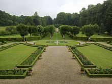
- Park of the Silière, Monument historique
- Vergentière garden
Web links
Commons : Cohons - collection of images, videos and audio files

