Bourguignon-lès-Morey
| Bourguignon-lès-Morey | ||
|---|---|---|
|
|
||
| region | Bourgogne-Franche-Comté | |
| Department | Haute-Saône | |
| Arrondissement | Vesoul | |
| Canton | Jussey | |
| Community association | Hauts du Val de Saône | |
| Coordinates | 47 ° 43 ' N , 5 ° 42' E | |
| height | 249-447 m | |
| surface | 9.84 km 2 | |
| Residents | 47 (January 1, 2017) | |
| Population density | 5 inhabitants / km 2 | |
| Post Code | 70120 | |
| INSEE code | 70089 | |
Bourguignon-lès-Morey is a commune in the French department of Haute-Saône in the region Bourgogne Franche-Comté .
geography
Bourguignon-lès-Morey is located at an altitude of 302 m above sea level, 14 kilometers west of Combeaufontaine and about 35 kilometers west-northwest of the city of Vesoul (as the crow flies). The village extends in the west of the department, in the undulating landscape on the southeast edge of the Langres plateau, in a slightly elevated position on the eastern slope of the Rigotte, at the western foot of the Montagne de la Roche .
The area of the 9.84 km² municipal area includes a section in the area of the plateau northwest of the Saône valley . From northeast to southwest, the area is crossed by the Rigotte valley, which drains the river into the Saône. The valley floodplain is an average of 250 m and has a maximum width of one kilometer. The valley is flanked on its northwest side by the heights of the Langres plateau (Popo, 326 m; Châtoillon, 322 m). To the east and south, a steep, wooded slope (Bois de Bourguignon) leads over to the ridge of the Montagne de la Roche and the Pain de Beurre to the north. At 447 m, the highest point in Bourguignon-lès-Morey is reached on the Point de Vue. In geological terms, the subsoil consists of sedimentary layers from the Lias ( Lower Jura ), while the Montagne de la Roche is mainly composed of limestone from the Middle Jura .
Neighboring communities of Bourguignon-lès-Morey are Pressigny and Charmes-Saint-Valbert in the north, La Roche-Morey in the east, Fouvent-Saint-Andoche in the south and Farincourt and Voncourt in the west.
history
The area of Bourguignon was already settled in prehistoric times. The earliest evidence of human presence is a Neolithic rampart. There was also a settlement here in Gallo-Roman times. In the Middle Ages, Bourguignon was part of the Free County of Burgundy and in that part of the Bailliage d'Amont area . The area was part of the Morey lordship which first belonged to the Vergy family, from the 14th century to the Montfaucon and from the 16th century to the Rye. As a border town, Bourguignon suffered greatly during the wars in the 16th and 17th centuries. Together with Franche-Comté , the village finally came to France with the Peace of Nijmegen in 1678. Today, Bourguignon-lès-Morey is a member of the communal association Communauté de communes des Belles Fontaines, which comprises 10 villages .
Attractions
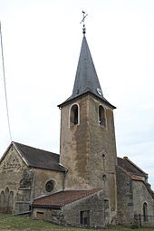
The church of Bourguignon-lès-Morey was built in the 19th century in the neo-Gothic style. Parts of the previous building, in particular the Gothic choir and the side chapels from the 16th century, were integrated into the new building. The church houses a 15th century statue of St. Anne.
In the town center there are numerous houses that show the traditional style of the Haute-Saône. There is an archaeological museum in the Maison du Patrimoine (only open in July and August). A tower bears witness to the former mansion.
population
| Population development | |
|---|---|
| year | Residents |
| 1962 | 152 |
| 1968 | 151 |
| 1975 | 146 |
| 1982 | 120 |
| 1990 | 71 |
| 1999 | 54 |
| 2006 | 48 |
With 47 inhabitants (January 1, 2017), Bourguignon-lès-Morey is one of the smallest communities in the Haute-Saône department. During the entire 20th century, there was a significant population decline (in 1891 there were still 314 people).
Economy and Infrastructure
Bourguignon-lès-Morey is still today a predominantly agricultural village (arable farming, viticulture, fruit growing and cattle breeding). Outside of the primary sector there are few jobs in town. Some workers are also commuters who work in the larger towns in the area.
The village is located off the major thoroughfares on a departmental road that leads from Pierrecourt to Malvillers . There are other road connections with Morey and Pressigny.

