Villers-le-Sec (Haute-Saône)
| Villers-le-Sec | ||
|---|---|---|
|
|
||
| region | Bourgogne-Franche-Comté | |
| Department | Haute-Saône | |
| Arrondissement | Vesoul | |
| Canton | Villersexel | |
| Community association | Triangle Vert | |
| Coordinates | 47 ° 36 ' N , 6 ° 13' E | |
| height | 258-389 m | |
| surface | 11.11 km 2 | |
| Residents | 531 (January 1, 2017) | |
| Population density | 48 inhabitants / km 2 | |
| Post Code | 70000 | |
| INSEE code | 70563 | |
| Website | http://www.villerslesec.fr/ | |
Villers-le-Sec is a commune in the French department of Haute-Saône in the region Bourgogne Franche-Comté .
geography
Villers-le-Sec is located at an altitude of 279 m above sea level, about five kilometers southeast of the city of Vesoul (as the crow flies). The village extends in the central part of the department, on a plateau southeast of the Vesoul basin, on the western edge of the Bois de Noroy plateau .
The area of the 11.11 km² large municipality covers a section in the area of the hill country between the basin of Vesoul and the valley of the Ognon . The main part of the area is occupied by the Villers-le-Sec plateau, which is embedded as a hollow in the surrounding heights. It extends in the north-west-south-east direction, has a maximum width of four kilometers and averages 270 m. Agricultural use predominates here. The hollow is flanked in the east by the wooded heights of the Bois de Noroy (up to 320 m). To the southeast, the community area extends to the heights that mark the watershed between Durgeon and Ognon. At 389 m, the highest point in Villers-le-Sec is reached on the Montcuchot in the far south.
From a structural geological point of view, the area around Villers-le-Sec has a complicated structure. It is traversed by numerous faults running in a southwest-northeast direction. The subsoil consists of an alternating layer of calcareous and sandy-marly sediments from the middle Jurassic period . There are no above-ground rivers in the entire area because the rainwater seeps into the karstified subsoil.
In addition to the actual village, Villers-le-Sec includes various hamlets and farms:
- Les Belles Baraques (285 m) in the hollow on the eastern edge of the Bois de Belle Côte
- Saint-Igny (295 m) at the southern foot of the Grand Mont
- Les Marcassins (306 m) at the northern foot of Montcuchot
- Granges Mercier (300 m) at the northern foot of Montcuchot
Villers-le-Sec's neighboring municipalities are Colombe-lès-Vesoul in the north, Noroy-le-Bourg in the east, Dampierre-sur-Linotte and Neurey-lès-la-Demie in the south, and Quincey in the west.
history
In the Middle Ages, Villers-le-Sec belonged to the Free County of Burgundy and in it to the area of the Bailliage d'Amont . The lords of Montaigu held local rule. Together with Franche-Comté , the village finally came to France with the Peace of Nijmegen in 1678. There was a change of area in 1807 when the previously independent Saint-Igny (1806: 41 inhabitants) was incorporated into Villers-le-Sec. Towards the end of the 19th century, the village was connected to the French rail network with the opening of the tram line from Vesoul to Montbozon . However, the line was stopped again in the 20th century. Today Villers-le-Sec is a member of the community association Communauté de communes des Grands Bois, which comprises 12 localities .
Attractions
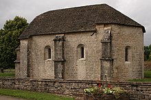
The Saint-Denis church was rebuilt in 1774 and redesigned in 1835. In the old town center there are various houses from the 17th and 18th centuries, which show the characteristic style of the Haute-Saône. In Saint-Igny there is a single-nave Romanesque chapel dating back to the 12th and 13th centuries. It has been classified as a Monument historique since 1979 and houses a statue of Christ (15th century) as well as a statue of the Madonna and a statue of Saint Aignan (16th century).
population
| Population development | |
|---|---|
| year | Residents |
| 1962 | 237 |
| 1968 | 242 |
| 1975 | 250 |
| 1982 | 350 |
| 1990 | 456 |
| 1999 | 483 |
| 2006 | 524 |
With 530 inhabitants (2007) Villers-le-Sec is one of the smaller communities in the Haute-Saône department. After the population had decreased significantly in the first half of the 20th century (412 people were counted in 1881), the population has continued to grow steadily since the mid-1970s. Since then the number of inhabitants has doubled.
Economy and Infrastructure
Until well into the 20th century, Villers-le-Sec was predominantly a village characterized by agriculture (arable farming, fruit growing and cattle breeding) and forestry. Today there are some local small businesses, in particular a transport company and a precision engineering workshop. In the last few decades the village has transformed into a residential community. Many workers are therefore commuters who go to work in the Vesoul agglomeration.
The village is well developed in terms of traffic. It is close to the main road D9, which leads from Vesoul to Villersexel . Other road connections exist with Colombe-lès-Vesoul and Dampierre-sur-Linotte.

