Bougey
| Bougey | ||
|---|---|---|
|
|
||
| region | Bourgogne-Franche-Comté | |
| Department | Haute-Saône | |
| Arrondissement | Vesoul | |
| Canton | Jussey | |
| Community association | Hauts du Val de Saône | |
| Coordinates | 47 ° 47 ' N , 5 ° 52' E | |
| height | 218-319 m | |
| surface | 8.56 km 2 | |
| Residents | 93 (January 1, 2017) | |
| Population density | 11 inhabitants / km 2 | |
| Post Code | 70500 | |
| INSEE code | 70078 | |
Bougey is a municipality in the French department of Haute-Saône in the region Bourgogne Franche-Comté .
geography
Bougey is located at an altitude of 235 m above sea level, six kilometers southwest of Jussey and about 28 kilometers northwest of the city of Vesoul (as the crow flies). The village extends in the north-western part of the department, in a valley basin south of the Ougeotte in the eastern foothills of the heights of Cherlieu.
The area of the 8.56 km² municipal area comprises a section of the undulating landscape west of the upper Saône valley. The central part of the area is taken up by the alluvial lowland of Bougey, which averages 230 m. The depression is around two kilometers wide and is drained by the Dorfbach to the northeast to the Ougeotte. The depression is flanked in the south by the ridge of the Grand Bois and the Bois des Noues , on which the highest point of Bougey is reached at 319 m. The community area extends to the west up to the heights of the Forêt de Cherlieu (315 m). These mountain ranges form the southeastern foothills of the Langres plateau. In geological and tectonic terms, they consist of alternating layers of sandy-marl and calcareous sediments of the Lias ( Lower Jurassic ). The northern border mostly runs along the Ougeotte, which drains the area to the Saône.
Neighboring municipalities to Bougey are Jussey in the north, Gevigney-et-Mercey and Augicourt in the east, Oigney in the south and Montigny-lès-Cherlieu in the west.
history
Remains from Gallo-Roman times (wall foundations and steles) indicate a very early settlement of the area. The church of Bougey is mentioned in a document in 1127. Since the 13th century, it was owned by the Cherlieu Monastery . In the Middle Ages, the village belonged to the Free County of Burgundy and in that part of the Bailliage d'Amont . Bougey formed its own lordship, which belonged to the Lords of Pesmes before it passed to a branch of the Grammont in the 15th century. Together with the Franche-Comté , Bougey finally came to France with the Peace of Nijmegen in 1678. Today Bougey is a member of the communauté de communes des Vertes Vallées, comprising eight localities .
Attractions
The village church of Bougey was rebuilt in 1851. It houses altars from the 18th century and several tombstones.
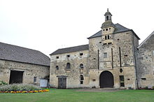
The current structure of the castle, which is classified as a monument historique , dates from 1581. The large complex has a round tower, a gate tower from the 17th century and remains of the former walling.
population
| Population development | |
|---|---|
| year | Residents |
| 1962 | 131 |
| 1968 | 125 |
| 1975 | 91 |
| 1982 | 92 |
| 1990 | 97 |
| 1999 | 91 |
| 2006 | 86 |
With 93 inhabitants (January 1, 2017) Bougey is one of the smallest municipalities in the Haute-Saône department. After the population had decreased significantly in the first half of the 20th century (346 people were counted in 1886), only minor fluctuations have been recorded since the mid-1970s.
Economy and Infrastructure
Up until well into the 20th century, Bougey was a village dominated by agriculture (arable farming, fruit growing and cattle breeding). Today there are some local small businesses. In the last few decades the village has transformed into a residential community. Many workers are therefore commuters who work in the larger towns in the area.
The place is off the major thoroughfares on a department road that leads from Jussey to Oigney. Other road connections exist with Gevigney, Augicourt, Cherlieu and Montigny-lès-Cherlieu.

