Larians-et-Munans
| Larians-et-Munans | ||
|---|---|---|
|
|
||
| region | Bourgogne-Franche-Comté | |
| Department | Haute-Saône | |
| Arrondissement | Vesoul | |
| Canton | Rioz | |
| Community association | Pays de Montbozon et du Chanois | |
| Coordinates | 47 ° 25 ' N , 6 ° 14' E | |
| height | 231-273 m | |
| surface | 2.50 km 2 | |
| Residents | 260 (January 1, 2017) | |
| Population density | 104 inhabitants / km 2 | |
| Post Code | 70230 | |
| INSEE code | 70296 | |
Larians-et-Munans is a municipality in the French department of Haute-Saône in the region Bourgogne Franche-Comté .
geography
Larians-et-Munans is located at an altitude of 240 m above sea level, six kilometers south-southwest of Montbozon and about 23 kilometers south of the city of Vesoul (as the crow flies). The village extends in a slightly elevated position in a loop of the Ognon , on the north-western edge of the hill country that extends between the river valleys of Ognon and Doubs .
The area of the 2.50 km² large municipal area covers a section of the middle Ognon Valley. In the east, south and west the border runs along the Ognon, which extends here with an arc far to the south and flows through a lowland about 500 to 1000 meters wide. From the course of the river, the community area extends northward over the alluvial plain , which is on average 235 m, to the adjacent plateau. This consists of limestone layers from the upper Jurassic period , lies at around 260 m and is mainly covered with arable and meadow land. Here, at 273 m, the highest point of Larians-et-Munans is reached.
The double community consists of the districts Larians (in the loop of the Ognon) and Munans (slightly elevated north of the valley floor). Neighboring municipalities of Larians-et-Munans are Loulans-Verchamp and Maussans in the north, Ollans in the east, Cendrey in the south and Flagey-Rigney in the west.
history

Larians was first mentioned in a document in 1187. The origin of the place name has not been clearly established. The name could go back to the Celtic word lar (river bend) or to the personal name Laderich . In the Middle Ages, the village belonged to the Free County of Burgundy and in that part of the Bailliage d'Amont . Munans formed its own little lordship in it. Together with Franche-Comté , Larians and Munans finally came to France with the Peace of Nijmegen in 1678.
At the end of the 17th century, a blast furnace was put into operation near Larians , which established the location for the later smelter . In the 18th century this was mainly used for military purposes (making bullets and cannons). Since the time of the French Revolution , Larians and Munans formed a double community. The blast furnace ceased operations in 1843 and was replaced by a foundry, which from then on mainly produced ovens and kitchen items. Today Larians-et-Munans is a member of the Pays de Montbozon et du Chanois municipal association .
Attractions
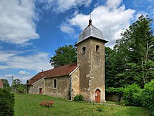
The Church of the Assumption of Mary in Larians is of medieval origin, but it has been destroyed several times. With the exception of a Gothic side chapel (15th century), the current structure dates from the 18th century. Two industrialist mansions date from the 19th and early 20th centuries. In Munans there is a castle that was built in the 17th and 18th centuries and is flanked by two towers.
population
| Population development | |
|---|---|
| year | Residents |
| 1962 | 217 |
| 1968 | 195 |
| 1975 | 195 |
| 1982 | 255 |
| 1990 | 206 |
| 1999 | 194 |
| 2016 | 252 |
With 194 inhabitants (1999) Larians-et-Munans is one of the small communities in the Haute-Saône department. After the population had decreased significantly in the first half of the 20th century (in 1896 330 people were still counted), population growth was recorded around 1980. Since then, however, the number of inhabitants has decreased again by almost 25%.
Economy and Infrastructure
Larians-et-Munans was an important location for the iron processing industry from an early age. The water power of the Ognon has been used to operate mills since the 14th century. Today there are two metalworks as well as various local small-scale businesses and some farms. A big sports festival takes place every summer.
The village is located away from the major thoroughfares on a department road that leads from Loulans-Verchamp to Ollans. Another road connection is with Maussans.

