Polaincourt-et-Clairefontaine
| Polaincourt-et-Clairefontaine | ||
|---|---|---|
|
|
||
| region | Bourgogne-Franche-Comté | |
| Department | Haute-Saône | |
| Arrondissement | Vesoul | |
| Canton | Port-sur-Saône | |
| Community association | Terres de Saône | |
| Coordinates | 47 ° 53 ' N , 6 ° 4' E | |
| height | 228-362 m | |
| surface | 21.40 km 2 | |
| Residents | 734 (January 1, 2017) | |
| Population density | 34 inhabitants / km 2 | |
| Post Code | 70210 | |
| INSEE code | 70415 | |
 Mairie Polaincourt-et-Clairefontaine |
||
Polaincourt-et-Clairefontaine is a municipality in the French department of Haute-Saône in the region Bourgogne Franche-Comté .
geography
Polaincourt-et-Clairefontaine is located at an altitude of 285 m above sea level, five kilometers south-southwest of Vauvillers and about 30 kilometers north-northwest of the city of Vesoul (as the crow flies). The village extends in the northern part of the department, on a plateau north of the Grand Bois .
The area of the municipal area of 21.40 km² covers a section in the gently undulating landscape east of the upper Saône valley . The central part of the area is occupied by the Polaincourt plateau, which is an average of 300 m. It is mainly used for agriculture, but there are also larger forest areas, especially along the municipal boundaries. The plateau is subdivided by various hollows and dry valleys . Above-ground running waters are only sparsely available: in the west the Ruisseau des Prés , which rises near Hurecourt, but drains away again after a short walk. A dry valley continues to the Ruisseau de la Sacquelle , which flows into the Saône at Montureux-lès-Baulay . The Ruisseau du Batiqueux , a tributary of the Superbe, runs right on the south-eastern edge of the area . The rainwater therefore mostly seeps into the porous subsoil.
The area is limited in the north by the height of Hurecourt (up to 342 m), in the north-west by Bois Lessus (310 m), in the south by the extensive forest of the Grand Bois , in which the highest point of Polaincourt-et Clairefontaine is reached, and to the southeast by the forest of Clairefontaine. With a narrow strip, the community area extends southwards into the valley of the Superbe . From a geological and tectonic point of view, the terrain consists mainly of shell limestone from the Middle Triassic . Sandy-marl and calcareous sediments, which were deposited during the Lias ( Lower Jurassic ) , also emerge in various places .
The double community consists of the main town Polaincourt (285 m) on the high plateau and the settlement Clairefontaine (250 m) in a side valley of the Superbe on the edge of the Grand Bois. Neighboring municipalities of Polaincourt-et-Clairefontaine are Hurecourt and Montdoré in the north, Melincourt and Anchenoncourt-et-Chazel in the east, Saint-Rémy-en-Comté , Senoncourt and Contréglise in the south and Saponcourt and Ormoy in the west.
history
Remains of a Roman traffic route point to an early inspection and probably also settlement of the area. The Clairefontaine Cistercian monastery was founded in 1131. Its monks cleared the area and laid the foundation for settlement. Polaincourt is first mentioned in a document in 1150. In the Middle Ages, the place belonged to the Free County of Burgundy and in it to the area of the Bailliage d'Amont . Local rule was held by the Viscounts of Vesoul, Lords of Faucogney. Clairefontaine Monastery was destroyed for the first time by the Grandes Compagnies in 1361 . Later it was sacked in 1569 by the troops of Duke Wolfgang von Pfalz-Zweibrücken , plundered in 1595 by those under Tremblecourt and again devastated in 1636 as part of the Thirty Years War.
Together with the Franche-Comté , Polaincourt finally came to France with the Peace of Nijmegen in 1678. During the French Revolution, the monastery was secularized and its goods declared state property. From 1804 to 1932 the buildings housed a faience factory and from 1938 a hospital. Today Polaincourt-et-Clairefontaine is a member of the community association Communauté de communes Agir Ensemble, which comprises 13 localities .
Attractions

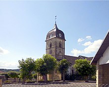
The Saint-Martin church shows Gothic styles, but has been changed several times. The nave dates from the 16th century, the transept and the choir from the 19th century, and the richly carved pulpit from the 17th century. The convent buildings of the former Clairefontaine monastery that are preserved today were built in the 18th century and are classified as a monument historique ; some remains of the 12th century cloister are still visible.
population
| Population development | |
|---|---|
| year | Residents |
| 1962 | 931 |
| 1968 | 1,048 |
| 1975 | 1,085 |
| 1982 | 1,221 |
| 1990 | 1,187 |
| 1999 | 900 |
| 2006 | 760 |
With 734 inhabitants (January 1, 2017), Polaincourt-et-Clairefontaine is one of the medium-sized communes in the Haute-Saône department. After the population had initially decreased significantly in the first half of the 20th century (917 people were still counted in 1911), the population grew steadily from 1940 to 1980. During this time the number of inhabitants has more than doubled. A decrease of 35% has been observed again since 1990.
Economy and Infrastructure
Until well into the 20th century, Polaincourt-et-Clairefontaine was a village dominated by agriculture (arable farming, viticulture and cattle breeding) and forestry. Today there are various small and medium-sized businesses, including a factory that makes agricultural implements and machines. A psychiatric clinic is housed in the Clairefontaine buildings. Many workers are also commuters who work in the larger towns in the area.
The village is located off the major thoroughfares on a department road that leads from Vauvillers to Faverney . Further road connections exist with Saponcourt, Hurecourt, Melincourt and Anchenoncourt.

