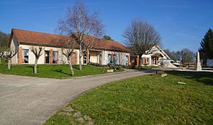
Vallerois-Lorioz
| Vallerois-Lorioz | ||
|---|---|---|

|
|
|
| region | Bourgogne-Franche-Comté | |
| Department | Haute-Saône | |
| Arrondissement | Vesoul | |
| Canton | Villersexel | |
| Community association | Pays de Montbozon et du Chanois | |
| Coordinates | 47 ° 34 ' N , 6 ° 9' E | |
| height | 305-430 m | |
| surface | 6.31 km 2 | |
| Residents | 370 (January 1, 2017) | |
| Population density | 59 inhabitants / km 2 | |
| Post Code | 70000 | |
| INSEE code | 70517 | |

|
||
Vallerois-Lorioz is a municipality in the French department of Haute-Saône in the region Bourgogne Franche-Comté .
geography
Vallerois-Lorioz is located at an altitude of 356 m above sea level, about seven kilometers south of Vesoul (as the crow flies). The village is located in the central part of the department, on a hill to the northeast of the Vellefaux basin in the hilly landscape that stretches between the river valleys of Saône in the north-west and the Ognon in the south-east.
The area of the 6.31 km² municipal area includes a section in the hilly area south of Vesoul. The central part of the area is occupied by a hollow, which is an average of 330 m. It has a width of about 1.5 kilometers and is oriented towards the southwest-northeast. Agricultural use predominates here, while the surrounding heights are predominantly forest-covered. The hollow is flanked in the southeast by the Bois des Rêpes , the northern continuation of the Sainte-Anne ridge . At 430 m, the highest point of Vallerois-Lorioz is reached here. To the north of the village rises the hill of the Bois Rond (416 m) and to the west the municipal area extends into the Grand Bois de Vellefaux . The area consists of an alternating layer of sandy-marly and calcareous layers from the middle Jurassic period . There are no surface rivers in the entire municipal area because the rainwater seeps into the karstified subsoil.
The following settlements belong to Vallerois-Lorioz:
- Autricourt (314 m) in a valley on the eastern edge of the Bois Rond
- Besson (345 m) on the plateau north of the Bois Rond
The neighboring communities of Vallerois-Lorioz are Échenoz-la-Méline and La Demie in the north, Neurey-lès-la-Demie in the east, Filain in the south and Vellefaux in the west.
history
Vallerois-Lorioz was first mentioned in a document in 1131. In the Middle Ages, the village belonged to the Free County of Burgundy and in it to the area of the Bailliage d'Amont . Local rule was held by the noble family of Vallerois. After the death of Étienne de Vallerois, the rule passed to the Bellevaux monastery , which it held until the French Revolution. Vallerois was destroyed during the Thirty Years War and was uninhabited for a long time. Together with Franche-Comté , the place finally came to France with the Peace of Nijmegen in 1678. Since the time of the French Revolution, Vallerois-Lorioz and Autricourt have formed a single municipality. Today Vallerois-Lorioz is a member of the community association Communauté de communes du Chanois, which comprises six localities .
Attractions
On the ridge Sainte-Anne , the chapel and hermitage Sainte-Anne , which forms a pilgrimage destination since the 1520th The chapel dates from the 17th century. In Vallerois there is a wayside cross from the 16th century. Several houses that show the traditional style of the Haute-Saône also date from this period. In the lower part of the village there is a lavoir (19th century), the roof of which is supported by numerous columns. It was once used as a wash house and cattle trough.
population
| Population development | |
|---|---|
| year | Residents |
| 1962 | 92 |
| 1968 | 94 |
| 1975 | 151 |
| 1982 | 198 |
| 1990 | 205 |
| 1999 | 206 |
| 2006 | 325 |
With 342 inhabitants (2007) Vallerois-Lorioz is one of the smaller communities in the Haute-Saône department. After the population in the first half of the 20th century had always been in the range between 80 and 140 people, there has been significant population growth since the beginning of the 1970s. Since then, the number of inhabitants has more than tripled.
Economy and Infrastructure
Until well into the 20th century, Vallerois-Lorioz was primarily a village characterized by agriculture (arable farming, fruit growing and cattle breeding) and forestry. Today there are some local small businesses. In the last few decades the village has transformed into a residential community. Many workers are therefore commuters who go to work in the Vesoul agglomeration.
The village is well developed in terms of traffic. It is close to the main road N57 that goes from Vesoul to Besançon . In the area of Vallerois-Lorioz it has been expanded to four lanes in sections. Other road connections exist with Vellefaux, Échenoz-la-Méline and Neurey-lès-la-Demie.
