
Ognon
| Ognon | ||
 |
||
| Data | ||
| Water code | FR : U10-0400 | |
| location | France , Bourgogne-Franche-Comte region | |
| River system | Rhône | |
| Drain over | Saône → Rhône → Mediterranean | |
| source | in the Vosges , southeast of the Col des Croix 47 ° 50 ′ 58 ″ N , 6 ° 46 ′ 24 ″ E |
|
| Source height | approx. 910 m | |
| muzzle | opposite Heuilley-sur-Saône in the Saône Coordinates: 47 ° 19 ′ 44 ″ N , 5 ° 28 ′ 16 ″ E 47 ° 19 ′ 44 ″ N , 5 ° 28 ′ 16 ″ E |
|
| Mouth height | approx. 190 m | |
| Height difference | approx. 720 m | |
| Bottom slope | approx. 3.4 ‰ | |
| length | 214 km | |
| Catchment area | 2308 km² | |
| Discharge at the Pesmes A Eo gauge : 1970 km² |
MQ 1964 - 2007 Mq 1964 - 2007 |
34 m³ / s 17.3 l / (s km²) |
| Left tributaries | Rahin , Scey | |
| Right tributaries | Lauzin , Linotte , Tounolle | |
| Flowing lakes | Etang Potou , Etang de la Plaine | |
| Small towns | Lure | |
 The Ognon near Lure |
||
The Ognon is a river in eastern France that runs mainly in the Bourgogne-Franche-Comté region . It rises in the Vosges , southeast of the Col des Croix . Its source is located in the municipality of Haut-du-Them-Château-Lambert at an altitude of 910 meters and is in the Ballons des Vosges Regional Nature Park . He generally drained southwest flows in many meanders through a water-rich valley and flows after 214 kilometers across from Heuilley-sur-Saône as a left tributary to the up there nearly equal length Saône .
Crossed departments
- Upper Saone (70)
- Doubs (25)
- Jurassic (39)
- Cote-d'Or (21)
The river rises in the Haute-Saône department, forms the border with the neighboring Doubs and Jura departments over long stretches and changes in its mouth section to the Côte-d'Or department, where it reaches the Saône.
Places on the river
- Haut-du-Them-Château-Lambert
- Mélisey
- Lure
- Villersexel
- Rougemont
- Ollans
- Voray-sur-l'Ognon
- Geneuille
- Marnay
- Thervay
- Pesmes
- Broye-Aubigney-Montseugny
Attractions
- Saut de l'Ognon artificial waterfall near the town of Servance with a 9-meter drop; When the water flow is abundant, the short barrier wall, which was built in place of the earlier, narrowly indented cataracts in the area of a valley sill formed by cold-age glaciers, is barely noticeable .
- River landscapes of the Ognon
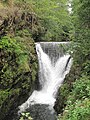
Waterfall (artificial) of the Ognon near Servance

The upper Ognon at Lure

The lower Ognon at Pesmes


See also
Web links
- Website of the Association of Historic Places in the Ognon Valley (French - English)
- Website of the Ballon des Vosges Regional Nature Park
Remarks
- ↑ a b geoportail.fr (1: 16,000)
- ↑ a b c The information on the length of the river is based on the information about the Ognon at SANDRE (French), accessed on March 14, 2009, rounded to full kilometers.
- ↑ station U1084010 Pesmes , Ministère de l'Ecologie, du Développement Durable et de l'Energie, accessed on 20 March 2019
- ↑ IGN -Géoportail: Tool 'Mésures - Profile altimétrique'