
Villersexel
| Villersexel | ||
|---|---|---|

|
|
|
| region | Bourgogne-Franche-Comté | |
| Department | Haute-Saône | |
| Arrondissement | Lure | |
| Canton | Villersexel (main town) | |
| Community association | Pays de Villersexel | |
| Coordinates | 47 ° 33 ' N , 6 ° 26' E | |
| height | 257-318 m | |
| surface | 13.19 km 2 | |
| Residents | 1,441 (January 1, 2017) | |
| Population density | 109 inhabitants / km 2 | |
| Post Code | 70110 | |
| INSEE code | 70561 | |
| Website | www.villersexel.fr | |

|
||

Villersexel (German outdated Sechsweiler ) is a municipality in the French department of Haute-Saône and the capital of the canton of the same name.
geography
The place is located in a slightly hilly landscape above the river Ognon , at the confluence of its left tributary Scey , about 46 kilometers northeast of Besançon , 24 km southeast of Vesoul and 30 kilometers west of Montbéliard .
Neighboring municipalities
Aillevans in the north, Saint-Sulpice in the northeast, Villers-la-Ville in the east, Les Magny in the south, Autrey-le-Vay in the southwest, Moimay in the west and Oppenans in the northwest.
history
Villersexel is likely to have received its name - like other neighboring communities such as Uzelle - from migrating Saxon Thuringians in the 7th century.
The battle at Villersexel on January 9, 1871 was an episode of the Franco-German War .
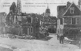
View of the destruction of Villersexel

German artillery in front of the ruins of the castle


Since 2000, Villersexel has been a member and seat of the community association Communauté de communes du Pays de Villersexel (CCPV), which comprises 33 localities .
Demographics
| 1962 | 1968 | 1975 | 1982 | 1990 | 1999 | 2006 |
|---|---|---|---|---|---|---|
| 1124 | 1191 | 1326 | 1516 | 1460 | 1444 | 1423 |
Buildings and sights

- Saint-Nicolas church (rebuilt between 1755 and 1758, facade and tower from 1780)
- Rectory (1753)
- Les Grammont Castle (rebuilt in 1882 on the site of a previous building destroyed in 1871, now a hotel)
- Hôpital de Grammont (1753)
traffic
Villersexel is located a little off the main road traffic and can only be reached via departmental roads (D 9 from Vesoul and Montbéliard , D 486 from Lure and D 50 from Baume-les-Dames ). The closest motorway is the A 36 / E 60 , which can be reached via the D 50 at the Baume-les-Dames junction, approx. 20 km away .
The high-speed railway line LGV Rhin-Rhône , opened in 2011, runs 1.5 km southwest of the village. The community had a train station on the Montbozon – Lure railway line. The line was last used for the transport of materials for the construction of the LGV, the connecting line from the Travaux base to the LGV was converted into the town's bypass in 2012.
Twin town
- Schönau in the Black Forest , Germany