
Creveney
| Creveney | ||
|---|---|---|
|
||
| region | Bourgogne-Franche-Comté | |
| Department | Haute-Saône | |
| Arrondissement | Lure | |
| Canton | Lure-1 | |
| Community association | Triangle Vert | |
| Coordinates | 47 ° 41 ′ N , 6 ° 18 ′ E | |
| height | 249-331 m | |
| surface | 2.44 km 2 | |
| Residents | 57 (January 1, 2017) | |
| Population density | 23 inhabitants / km 2 | |
| Post Code | 70240 | |
| INSEE code | 70188 | |

|
||

Creveney is a municipality in the French department of Haute-Saône in the region Bourgogne Franche-Comté .
geography
Creveney is located at an altitude of 275 m above sea level, one and a half kilometers southeast of Saulx and about twelve kilometers northeast of the city of Vesoul (as the crow flies). The village extends in the central part of the department, east of the Saulx basin, in a valley at the source of the Ruisseau de Bognon .
The area of the 2.44 km² large municipal area includes a section in the area of the Saulx basin. The central part of the area is occupied by the Creveney basin, in which the Ruisseau de Bognon rises. It provides drainage to the west to the Durgeon . To the east, a hill leads over to the lowland of the Ruisseau de Châteney (tributary of the Colombine ), which marks the eastern boundary for a short distance. The agricultural hollow of Creveney is flanked in the south by the forest heights of the Grand Bois and the Bois Charmont . At 331 m, the highest point in Creveney is reached on the Bois Charmont . From a geological and tectonic point of view, the terrain consists of alternating layers of sandy-marl and calcareous sediments that were deposited during the Lias ( Lower Jurassic ).
The neighboring municipalities of Creveney are Saulx in the west and north, Châtenois in the east and Colombotte in the south.
history
Finds of gold and silver coins in the Grand Bois and in the Le Candal corridor indicate an early inspection and settlement of the area. Creveney is first mentioned in 1187 under the name Crevenie . The place name probably goes back to the Gallic personal name Cravennus . In the Middle Ages, the village belonged to the Free County of Burgundy and in that part of the Bailliage d'Amont . Local rule was held by the lords of Saulx and later those of Châtenois. Bithaine Monastery also had property and rights in Creveney. Together with Franche-Comté , the place finally came to France with the Peace of Nijmegen in 1678. Bituminous slate was mined and oil was extracted from Creveney between 1929 and 1934 . Today Creveney is a member of the community association Communauté de communes du Pays de Saulx, which comprises 17 villages .
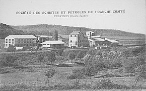
Oil shale mining at Creveney in the 1930s
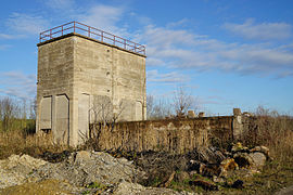
The ruins in 2015


Attractions
At the entrance to the village there is a Calvaire that was built in 1879.
population
| Population development | |
|---|---|
| year | Residents |
| 1962 | 84 |
| 1968 | 90 |
| 1975 | 57 |
| 1982 | 70 |
| 1990 | 66 |
| 1999 | 57 |
| 2006 | 66 |
With 57 inhabitants (January 1, 2017) Creveney is one of the smallest municipalities in the Haute-Saône department. After the population had decreased in the first half of the 20th century (135 people were still counted in 1891), only relatively minor fluctuations have been recorded since the mid-1970s.
Economy and Infrastructure
Creveney is still a predominantly agricultural (arable, fruit growing and cattle breeding) and forestry village. Outside of the primary sector there are few jobs in town. Some workers are therefore commuters who work in the larger towns in the area and in the Vesoul agglomeration.
The village is located off the major thoroughfares on a department road that leads from Saulx to Velleminfroy . Creveney had a train station on the Paris – Mulhouse line . This was closed at the end of the 20th century.