
Francalmont
| Francalmont | ||
|---|---|---|
|
||
| region | Bourgogne-Franche-Comté | |
| Department | Haute-Saône | |
| Arrondissement | Lure | |
| Canton | Saint-Loup-sur-Semouse | |
| Community association | Haute Comté | |
| Coordinates | 47 ° 50 ′ N , 6 ° 16 ′ E | |
| height | 234-304 m | |
| surface | 6.86 km 2 | |
| Residents | 120 (January 1, 2017) | |
| Population density | 17 inhabitants / km 2 | |
| Post Code | 70800 | |
| INSEE code | 70249 | |
 Mairie Francalmont |
||

Francalmont is a municipality in the French department of Haute-Saône in the region Bourgogne Franche-Comté .
geography
Francalmont is located at an altitude of 248 m above sea level, nine kilometers west-northwest of Luxeuil-les-Bains and about 26 kilometers north-northeast of the city of Vesoul (as the crow flies). The village extends in the northern part of the department, in a niche on the northern edge of the Lanterne valley .
The area of the 6.86 km² municipal area includes a section of the gently undulating landscape in the area of the lantern. From east to west, the area is crossed by the Lanterne alluvial valley , which drains the Saône . In the floodplain, the river draws several meanders, forms small river islands and has near-natural banks. The valley level lies at an average of 238 m and has a width of around two kilometers. It is partly used for agriculture, partly with alluvial forest. In the lowland, the Rôge also flows more or less parallel to the Lanterne, into which it only flows at Briaucourt.
South of the lantern, an approximately 40 m high step leads to the wooded height of Boulay (288 m). It is made of red sandstone from the Lower Triassic . To the north, the municipal area extends over the Côte (285 m) up to the Bois de Varenne plateau . Here, at 304 m, the highest point of Francalmont is reached. It consists of an alternating layer of sandy-marly and calcareous sediments that were deposited during the Lias ( Lower Jurassic ).
The neighboring municipalities of Francalmont are Saint-Loup-sur-Semouse in the north, Hautevelle in the east, Ormoiche and Briaucourt in the south and Ainvelle in the west.
history
Remains from Gallo-Roman times indicate a very early settlement of the area. A grave stele was found here depicting a man with a scythe. It is now in the Vesoul Museum. In the Middle Ages Francalmont belonged to the Free County of Burgundy and in it to the area of the Bailliage d'Amont . It was assigned to the territory of Saint-Loup, which was under the lords of Faucogney. Together with Franche-Comté , the place finally came to France with the Peace of Nijmegen in 1678.
Attractions
The village church of Saint-Nicolas in Francalmont was rebuilt in the 18th century and houses rich furniture and paintings from this period. Behind the church there is a Gothic Calvaire . The former mansion dates from the 18th century. The Notre-Dame-de-Toutes-Grâces chapel (19th century) stands in a panoramic position on the La Côte hill.

Saint-Nicolas church
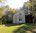
Notre-Dame-de-Toutes-Grâces chapel

Interior of the chapel


population
| Population development | |
|---|---|
| year | Residents |
| 1962 | 120 |
| 1968 | 116 |
| 1975 | 104 |
| 1982 | 115 |
| 1990 | 100 |
| 1999 | 123 |
| 2006 | 130 |
With 120 inhabitants (January 1, 2017) Francalmont is one of the small communities in the Haute-Saône department. After the population had decreased significantly in the first half of the 20th century (330 people were still counted in 1881), only minor fluctuations have been recorded since the early 1960s.
Economy and Infrastructure
Francalmont is still predominantly a village characterized by agriculture (arable farming, fruit growing and cattle breeding) and forestry. Outside of the primary sector there are few jobs in town. Some workers are therefore commuters who work in the larger towns in the area.
The village is away from the major thoroughfares. The main access is from the departmental road from Luxeuil-les-Bains to Conflans-sur-Lanterne . There are other road connections with Ainvelle and Hautevelle .