Magny-Danigon
| Magny-Danigon | ||
|---|---|---|

|
|
|
| region | Bourgogne-Franche-Comté | |
| Department | Haute-Saône | |
| Arrondissement | Lure | |
| Canton | Lure-2 | |
| Community association | Pays de Lure | |
| Coordinates | 47 ° 40 ′ N , 6 ° 36 ′ E | |
| height | 302-463 m | |
| surface | 7.52 km 2 | |
| Residents | 439 (January 1, 2017) | |
| Population density | 58 inhabitants / km 2 | |
| Post Code | 70200 | |
| INSEE code | 70318 | |
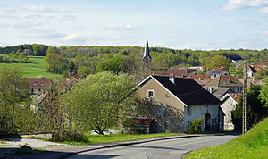
 Village view |
||
Magny-Danigon is a municipality in the French department of Haute-Saône in the region Bourgogne Franche-Comté .
geography
Magny-Danigon is located at an altitude of 310 m above sea level, eight kilometers east of Lure and about 20 kilometers west of the city of Belfort (as the crow flies). The village extends in the eastern part of the department, in a valley near the source of the Rognon , at the western foot of the heights of the Chérimont .
The area of the 7.52 km² municipal area comprises a section in the undulating landscape southeast of the Lure plain. The southern part of the area is taken up by the Rognon basin, which provides drainage to the southwest over the Scey to the Ognon . The alluvial low lies on average at 310 m and has a width of around 500 meters. The Rognon and its side streams are dammed up to fish ponds in several places ( Étang la Dame , Étang du Bois ). This area is mainly used for agriculture. From a geological and tectonic point of view, this part consists of alternating layers of calcareous and sandy-marl sediments that were deposited during the Lias (Lower Jurassic).
The western boundary is the La Noye Jeannin forest . To the north, the terrain gradually rises to the forest heights of the Bois Communal and the Bois de la Nanue . At 463 m, the highest point of Magny-Danigon is reached on the western roof of the Chérimont. The ridge is made of red sandstone from the lower Triassic . To the north it drops steeply with several protrusions and niches to the wide valley of the Rahin at the foot of the Vosges . The community area does not extend all the way to the Rahin, but only to its southern tributary Beuveroux , which marks the northern border.
Neighboring municipalities of Magny-Danigon are Ronchamp in the north, Champagney in the east, Clairegoutte , Andornay and Palante in the south and La Côte in the west.
history
Magny-Danigon is mentioned in a document in 1350 under the name Meingni dannegon . The names Magny d'Anagon (1427), Magny danagon (1502), Maingny dannegon (1553) and Magny damphugon (1622) have survived from a later period . The settlement was built around a castle that Hugues of Burgundy had built. In the Middle Ages, Magny-Danigon belonged to the Free County of Burgundy and in it to the area of the Bailliage d'Amont . In 1304 the place came to the lordship of Étobon and the county of Montbéliard . Magny-Danigon was annexed by the French king in 1674.
As early as the 18th century, Magny-Danigon developed into an important mining and commercial location. There was a tannery, two tool smiths, four nail smiths, pottery, a coal mine and gypsum quarry. The coal mine ( Houillères de Ronchamp ) was in operation until 1958. At that time, the Arthur de Buyer shaft was the deepest in France at 1010 m. Today Magny-Danigon is a member of the community association Communauté de communes du Pays de Lure, which comprises 22 localities .
Attractions
The Lutheran church of Magny-Danigon was rebuilt from 1864 to 1869 according to plans by Jean Baptiste Colard. In the same place, an earlier church started in 1773 gave way, one of the twenty churches in the county and once dependent areas, which were rebuilt or renovated on behalf of Karl Eugen during his long reign. Before that there was a previous building from the pre-Reformation period. Other sights include the fountain in the village square and the ruins of the former coal mine.
population
| Population development | |
|---|---|
| year | Residents |
| 1962 | 430 |
| 1968 | 386 |
| 1975 | 357 |
| 1982 | 378 |
| 1990 | 344 |
| 1999 | 403 |
| 2006 | 435 |
| 2016 | 442 |
With 439 inhabitants (January 1, 2017), Magny-Danigon is one of the smaller municipalities in the Haute-Saône department. After the population had decreased significantly since around 1930 (705 people were still counted in 1931), population growth has been recorded again since the beginning of the 1990s.
Economy and Infrastructure
Magny-Danigon was a village dominated by trade and coal mining from an early age. Today there are various small and medium-sized businesses, especially in the construction and plastics industries. There is also a pottery studio. In the last few decades the village has transformed into a residential community. Many workers are therefore commuters who go to work in the larger towns in the area and in the Belfort-Montbéliard agglomeration.
The village is located off the major thoroughfares on a departmental road that leads from La Côte to Clairegoutte. Another road connection exists with Ronchamp.
Web links
Individual evidence
- ↑ Lucienne Piquard, Magny-Sanigon: Les deux églises , pp. 6 and 8, accessed on January 23, 2016.
- ↑ Georges-Frédéric Goguel, Précis historique de la Réformation et des églises protestantes dans l'ancien comté de Montbéliard et ses dépendances , Paris: Marc-Aurel frères, 1841, p. 148.

