
Mandrevillars
| Mandrevillars | ||
|---|---|---|

|
|
|
| region | Bourgogne-Franche-Comté | |
| Department | Haute-Saône | |
| Arrondissement | Lure | |
| Canton | Héricourt-1 | |
| Community association | Pays d'Héricourt | |
| Coordinates | 47 ° 37 ' N , 6 ° 47' E | |
| height | 360-443 m | |
| surface | 3.03 km 2 | |
| Residents | 242 (January 1, 2017) | |
| Population density | 80 inhabitants / km 2 | |
| Post Code | 70400 | |
| INSEE code | 70330 | |
 Mairie Mandrevillars |
||

Mandrevillars is a municipality in the French department of Haute-Saône in the region Bourgogne Franche-Comté .
geography
Mandrevillars is located at an altitude of 369 m above sea level, about seven kilometers southwest of the city of Belfort (as the crow flies). The village extends to the west of the Burgundian Gate , in a broad valley north of Mont Vaudois.
The area of the 3.03 km² municipal area includes a section in the area of the Burgundian Gate. The central part of the area is crossed in a north-south direction by a stream that belongs to the upper catchment area of the Ruisseau de Brevilliers (tributary of the Lizaine ). This hollow is flanked in the east by the summit of the Bois du Mont , on which the highest elevation of Mandrevillars is reached at 443 m. A slightly undulating plateau extends to the west, which is approximately 380 m and is made up of marly sediments of the Lias ( Lower Jurassic ) and Triassic . The north-western border runs in a valley at the foot of the Brisée forest .
Neighboring municipalities of Mandrevillars are Châlonvillars in the north, Buc in the east, Échenans-sous-Mont-Vaudois in the south and Chagey in the west.
history
The municipality of Mandrevillars was already inhabited in prehistoric times, as evidenced by traces from the Neolithic on the Sous-la-Côte corridor and a burial ground from the La Tène period on the Combeaufol corridor. In the Middle Ages the village belonged to the Montbéliard domain. In 1748 Mandrevillars, which until then had been under the sovereignty of the Principality of Württemberg-Mömpelgard (Montbéliard) , finally came under contract to the French crown. At the end of 1972, Mandrevillars was merged with Châlonvillars (to form the municipality of Châlonvillars-Mandrevillars ), but in early 1989 it regained its independence. Since 2001 Mandrevillars has been a member of the Pays d'Héricourt, a community of 20 towns .
Attractions
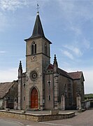
The Church of the Assumption ( Église de l'Assomption-de-la-Vierge-Marie ) in Mandrevillars was built in the 18th century.
- Church of the Assumption


population
| Population development | |
|---|---|
| year | Residents |
| 1962 | 80 |
| 1968 | 86 |
| 1975 | - |
| 1982 | - |
| 1990 | 123 |
| 1999 | 140 |
| 2007 | 211 |
With 242 inhabitants (January 1, 2017), Mandrevillars is one of the small communities in the Haute-Saône department. After the population in the first half of the 20th century was mostly in the range between 80 and 100 people, the population has continued to grow since the early 1970s. Since then the number of inhabitants has more than doubled.
Economy and Infrastructure
Until well into the 20th century, Mandrevillars was a village dominated by agriculture (arable farming, fruit growing and cattle breeding). The residents who work in the village still live mainly from their work in the first sector. Outside the primary sector there are few jobs in the village. However, many workers are commuters who work in Héricourt and in the agglomerations of Belfort and Montbéliard .
The village is located away from the major thoroughfares on a department road that leads from Brevilliers to Châlonvillars. The closest connection to the A36 motorway is around ten kilometers away. Another road connection is with Buc.