
Bouligney
| Bouligney | ||
|---|---|---|
|
||
| region | Bourgogne-Franche-Comté | |
| Department | Haute-Saône | |
| Arrondissement | Lure | |
| Canton | Port-sur-Saône | |
| Community association | Haute Comté | |
| Coordinates | 47 ° 54 ' N , 6 ° 14' E | |
| height | 231-357 m | |
| surface | 14.20 km 2 | |
| Residents | 410 (January 1, 2017) | |
| Population density | 29 inhabitants / km 2 | |
| Post Code | 70800 | |
| INSEE code | 70083 | |

Bouligney is a municipality in the French department of Haute-Saône in the region Bourgogne Franche-Comté .
geography
Bouligney is located at an altitude of 258 m above sea level, three kilometers west-northwest of Saint-Loup-sur-Semouse and about 31 kilometers north of the city of Vesoul (as the crow flies). The village extends in the far north of the department, in a hollow east of the Dorgeon valley, on the edge of the Vôge plateau .
The area of the 14.20 km² municipal area includes a section in the gently undulating landscape on the edge of the Vôge. The western border runs along the Dorgeon, which ensures the drainage of the area to the south via the Lanterne to the Saône . It flows through an alluvial lowland , which averages 235 m and is a maximum of one kilometer wide. From the course of the river, the municipal area extends eastward to the hill of Bouligney, which is divided by the hollows of several side valleys of the Dorgeon, including the Ruisseau de Pervas and the Ruisseau des Prés Bauquez . The area around Bouligney is predominantly used for agriculture.
To the north, the municipality extends into the extensive forest of the Grand Bois . The plateau rises slightly overall, but is interrupted by the basin of the Ruisseau du Chânet . On the plateau in the far north, at the transition to the Bois du Lyaumont , the highest point of Bouligney is reached at 357 m. In geological and tectonic terms, the southern part of the municipal area consists of shell limestone from the Middle Triassic . To the north there is a zone with sandy-marl and calcareous sediments that were deposited during the Lias ( Lower Jurassic ). Further north, in the Grand Bois, the red sandstone of the Lower Triassic comes to light.
The following hamlets belong to Bouligney:
- Granges d'Amalix (275 m) in the valley of the Ruisseau des Lauchères east of the Grand Bois
- Ruisseau des Écrevisses (280 m) in a cleared island in the Grand Bois
Neighboring municipalities of Bouligney are Fontenoy-le-Château and Aillevillers-et-Lyaumont in the north, Saint-Loup-sur-Semouse in the east, Anjeux in the south and Cuve in the west.
history
Bouligney is first mentioned in a document in 1150. In the Middle Ages, the village belonged to the Free County of Burgundy and in it to the area of the Bailliage d'Amont . Local rulership was shared between the Fontaine-lès-Luxeuil and Fleurey priories with a secular lord. In 1571, Bouligney was almost completely destroyed. Together with Franche-Comté , the place finally came to France with the Peace of Nijmegen in 1678.
Attractions
Bouligney Church was built in the 18th century and restored in the 19th century. The furnishings include furniture and choir stalls from the 18th century, a painting of the Resurrection of Christ and statues from the 17th and 18th centuries. Century. The Mairie - Lavoir and the covered wells (19th century) I. with a statue of Napoleon are as since 1997 Monument historique classified.
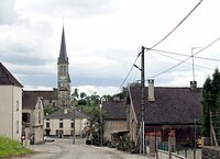
View to the Church of St. Eustachius
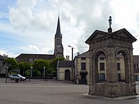
Mairie lavoir and covered fountain


population
| Population development | |
|---|---|
| year | Residents |
| 1962 | 430 |
| 1968 | 463 |
| 1975 | 418 |
| 1982 | 454 |
| 1990 | 481 |
| 1999 | 431 |
| 2006 | 434 |
With 410 inhabitants (January 1, 2017), Bouligney is one of the smaller municipalities in the Haute-Saône department. After the population had decreased significantly in the first half of the 20th century (719 people were still counted in 1886), only relatively minor fluctuations have been recorded since the early 1960s.
Economy and Infrastructure
Until well into the 20th century, Bouligney was primarily a village characterized by agriculture (arable farming, viticulture and cattle breeding) and forestry. Today there are some local small businesses, mainly in the wood and textile processing industries as well as service companies. In the last few decades the village has transformed into a residential community. Many workers are therefore commuters who work in the larger towns in the area.
The village is well developed in terms of traffic. It is on the main D417 road from Luxeuil-les-Bains to Bourbonne-les-Bains . Further road connections exist with Lyaumont and Anjeux.