Velleminfroy
| Velleminfroy | ||
|---|---|---|
|
|
||
| region | Bourgogne-Franche-Comté | |
| Department | Haute-Saône | |
| Arrondissement | Lure | |
| Canton | Lure-1 | |
| Community association | Triangle Vert | |
| Coordinates | 47 ° 40 ′ N , 6 ° 19 ′ E | |
| height | 278-379 m | |
| surface | 6.02 km 2 | |
| Residents | 298 (January 1, 2017) | |
| Population density | 50 inhabitants / km 2 | |
| Post Code | 70240 | |
| INSEE code | 70537 | |

|
||
Velleminfroy is a municipality in the French department of Haute-Saône in the region Bourgogne Franche-Comté .
geography
Velleminfroy is located at an altitude of 295 m above sea level, five kilometers southeast of Saulx and about 13 kilometers east-northeast of the city of Vesoul (as the crow flies). The village extends in the central part of the department, in a hollow south of the Colombine valley .
The area of the 6.02 km² municipal area covers a section in the undulating landscape between the basin of Vesoul in the west and the plain of Lure in the east. The central part of the area is occupied by the Velleminfroy basin, which is drained from the Dorfbach northwards to the Colombine. The Colombine, a tributary of the Durgeon , marks in parts the northern border. Their valley low lies at an average of 280 m and has a maximum width of one kilometer. Agricultural use prevails here. There is a mineral spring at the edge of the valley. To the north of the valley, the area extends into the forest of the Bois de Vaugirard .
The Velleminfroy basin is flanked by partly wooded, partly meadowland hills: in the east by the Bois de la Bougère (322 m), in the south by the Bois de Chassaigne (332 m) and the Haut de Theux (366 m) and in the west from the Valdoie , on which the highest point of Velleminfroy is reached at 379 m. With a narrow tip, the municipal area extends southwards into the lowland of the Ruisseau de la Prairie in the catchment area of the Ognon . From a geological and tectonic point of view, the terrain consists of alternating layers of sandy-marl and calcareous sediments that were deposited during the Lias ( Lower Jurassic ). In some places, shell limestone from the Middle Triassic also emerges.
Neighboring municipalities of Velleminfroy are Châtenois in the north, La Creuse and Pomoy in the east, Calmoutier in the south and Colombotte in the west.
history
Remains of a Gallo-Roman traffic route point to an early settlement of the area. Velleminfroy was first mentioned in a document as early as 815 under the name Villa Manfredi . In the Middle Ages, the village belonged to the Free County of Burgundy and in that part of the Bailliage d'Amont . The monastery of Luxeuil held local rule . Together with Franche-Comté , the place finally came to France with the Peace of Nijmegen in 1678. Today Velleminfroy is a member of the community association Communauté de communes du Pays de Saulx, which comprises 17 localities .
Attractions
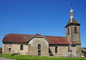
The village church of Velleminfroy was rebuilt in 1847 and has a richly carved altar and a baptismal font from the 18th century as well as several grave slabs. The Calvaire in the upper part of the village dates from the 15th century .
population
| Population development | |
|---|---|
| year | Residents |
| 1962 | 203 |
| 1968 | 172 |
| 1975 | 205 |
| 1982 | 221 |
| 1990 | 247 |
| 1999 | 277 |
| 2006 | 275 |
With 298 inhabitants (January 1, 2017), Velleminfroy is one of the small communities in the Haute-Saône department. After the population had decreased significantly in the first half of the 20th century (413 people were still counted in 1881), population growth has been recorded again since the beginning of the 1970s.
Economy and Infrastructure
Until well into the 20th century, Velleminfroy was primarily a village characterized by agriculture (arable farming, fruit growing and cattle breeding) and forestry. Today there are some local small businesses. In the last few decades the village has transformed into a residential community. Many employed people are therefore commuters who work in the larger towns in the area and in the agglomeration of Vesoul.
The village is well developed in terms of traffic. It is close to the main road N19 that runs from Vesoul to Belfort . Other road connections exist with Saulx and La Creuse.
