Coisevaux
| Coisevaux | ||
|---|---|---|
|
|
||
| region | Bourgogne-Franche-Comté | |
| Department | Haute-Saône | |
| Arrondissement | Lure | |
| Canton | Héricourt-2 | |
| Community association | Pays d'Héricourt | |
| Coordinates | 47 ° 35 ' N , 6 ° 42' E | |
| height | 336-498 m | |
| surface | 4.18 km 2 | |
| Residents | 327 (January 1, 2017) | |
| Population density | 78 inhabitants / km 2 | |
| Post Code | 70400 | |
| INSEE code | 70160 | |
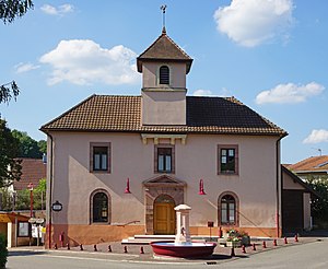
 Mairie Coisevaux |
||
Coisevaux is a municipality in the French department of Haute-Saône in the region Bourgogne Franche-Comté .
geography
Coisevaux is at an altitude of 362 m above sea level, four kilometers west of Héricourt and about eleven kilometers northwest of the city of Montbéliard (as the crow flies). The village extends to the west of the Burgundian Gate , in a hollow at the northwest foot of the Grand Bois .
The area of the 4.18 km² municipal area includes a section in the area of the Burgundian Gate. The central part of the area is crossed in a west-east direction by the valley lowlands of the Dorfbach and the Ruisseau de Champey , which have a width of about two kilometers. This hollow is flanked in the south by the ridge of the Grand Bois , which consists of a resistant layer of limestone from the middle Jurassic period and on which the highest point of Coisevaux is reached at 498 m. The area is drained to the Ruisseau de la Carpière (tributary of the Lizaine ), which is dammed up to the Étang Réchal , a fish pond. To the north, the community area extends to the edge of the hilly forest area Bois de Granges , which here is made of red sandstone .
Neighboring municipalities of Coisevaux are Luze in the north, Couthenans and Héricourt in the east, Verlans and Trémoins in the south and Champey in the west.
history
The municipality of Coisevaux was settled very early. Ceramic fragments from the Bronze Age were found in the Sarrazin's Grotto . Since the Middle Ages, Coisevaux has belonged to the rule of Héricourt, which was under the sovereignty of the Counts of Württemberg-Mömpelgard (Montbéliard) . In 1748 the village finally came under contract to the French crown. Since 2001 Coisevaux has been a member of the Communauté de communes du Pays d'Héricourt, comprising 20 localities .
population
| Population development | |
|---|---|
| year | Residents |
| 1962 | 124 |
| 1968 | 117 |
| 1975 | 123 |
| 1982 | 171 |
| 1990 | 211 |
| 1999 | 249 |
With 293 inhabitants (2004) Coisevaux is one of the small communities in the Haute-Saône department. After the population had decreased in the first half of the 20th century (220 people were still counted in 1886), strong population growth has been recorded since the mid-1970s. Since then the number of inhabitants has more than doubled.
Economy and Infrastructure
Until well into the 20th century, Coisevaux was primarily a village characterized by agriculture (arable farming, fruit growing and cattle breeding) and forestry. In addition, there are now some local small businesses. In the meantime, the village has also turned into a residential community. Many workers are therefore commuters who do their work in Héricourt and the agglomerations of Belfort and Montbéliard.
The village is very well developed in terms of traffic. It is close to the main road D9, which leads from Héricourt to Villersexel . The closest connection to the A36 motorway is around 14 km away. Other road connections exist with Couthenans and Trémoins.
Web links
- Information on the municipality of Coisevaux (French)
- Statistical data from the Insee on the population of Coisevaux (PDF file; 74 kB)
