Villers-lès-Luxeuil
| Villers-lès-Luxeuil | ||
|---|---|---|
|
|
||
| region | Bourgogne-Franche-Comté | |
| Department | Haute-Saône | |
| Arrondissement | Lure | |
| Canton | Saint-Loup-sur-Semouse | |
| Community association | Triangle Vert | |
| Coordinates | 47 ° 46 ′ N , 6 ° 17 ′ E | |
| height | 253-395 m | |
| surface | 9.10 km 2 | |
| Residents | 303 (January 1, 2017) | |
| Population density | 33 inhabitants / km 2 | |
| Post Code | 70300 | |
| INSEE code | 70564 | |
| Website | http://www.villers-les-luxeuil.com | |
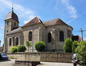
 Saint-Pierre church |
||
Villers-lès-Luxeuil is a commune in the French department of Haute-Saône in the region Bourgogne Franche-Comté .
geography
Villers-lès-Luxeuil is located at an altitude of 277 m above sea level, nine kilometers southwest of Luxeuil-les-Bains and about 20 kilometers north-northeast of the city of Vesoul (as the crow flies). The village extends in the northern part of the department, in a hollow on the western edge of the Luxeuil plain and the Lanterne valley , at the northern foot of the heights of the Bois de la Grande Brosse .
The area of the 9.10 km² municipal area comprises a section of the gently undulating landscape south of the Lanterne. The northeastern part of the area is occupied by the alluvial lowlands of the Lanterne. It is an average of 260 m and is around four kilometers wide. Agricultural use prevails here. The lantern marks the eastern border for a short distance.
To the west, the municipal area extends into the valley basin of the Dorfbach, which is flanked in the north by the Champs Montants (up to 320 m) and in the south by the forest hills of the Bois de la Grande Brosse . In this section, the subsoil is mainly composed of shell limestone from the Middle Triassic . Further to the south-west, the communal soil extends over a saddle into the wooded headwaters of the Durgeon and to the heights of the Bois de Dessus . At 395 m, the highest point in Villers-lès-Luxeuil is reached here. Here sandy, marly and calcareous sediments emerge, which were deposited during the Lias ( Lower Jurassic ).
Neighboring municipalities of Villers-lès-Luxeuil are Abelcourt and Sainte-Marie-en-Chaux in the north, Breuches in the east, Éhuns , Visoncourt and Mailleroncourt-Charette in the south and Meurcourt and Velorcey in the west.
history
The area around Villers was already populated in prehistoric times. The earliest evidence of man's presence comes from the Paleolithic . Wall foundations of a country estate were discovered from the Gallo-Roman times. In the Middle Ages Villers belonged to the Free County of Burgundy and in that part of the Bailliage d'Amont area . The monastery of Luxeuil held local rule . Together with Franche-Comté , the village finally came to France with the Peace of Nijmegen in 1678. Today, Villers-lès-Luxeuil is a member of the communal association Communauté de communes du Pays de Saulx, which comprises 17 villages .
Attractions
The Saint-Laurent church was rebuilt in the 18th century. It has valuable interior furnishings, including an octagonal baptismal font from 1541, a richly carved pulpit, paneling and furniture from the 18th century, and various statues. Also worth seeing are the three fountains and the lavoir from the 19th century, the roof of which is supported by several columns.
population
| Population development | |
|---|---|
| year | Residents |
| 1962 | 178 |
| 1968 | 187 |
| 1975 | 202 |
| 1982 | 212 |
| 1990 | 240 |
| 1999 | 305 |
| 2006 | 357 |
With 303 inhabitants (January 1, 2017) Villers-lès-Luxeuil is one of the smaller municipalities in the Haute-Saône department. After the population had decreased significantly in the first half of the 20th century (419 people were still counted in 1881), the population has continued to grow steadily since the early 1970s. Since then the number of inhabitants has doubled.
Economy and Infrastructure
Until well into the 20th century, Villers-lès-Luxeuil was primarily a village characterized by agriculture (arable farming, fruit growing and cattle breeding) and forestry. The water power of the village stream was previously used to operate a mill. Today there are a few local small businesses, including a wood processing company. In the last few decades the village has transformed into a residential community. Many workers are therefore commuters who work in the larger towns in the area.
The village is located off the major thoroughfares on a department road that leads from Sainte-Marie-en-Chaux to Mailleroncourt-Charette. Further road connections exist with Éhuns and Velorcey.
