
Plainemont
| Plainemont | ||
|---|---|---|
|
||
| region | Bourgogne-Franche-Comté | |
| Department | Haute-Saône | |
| Arrondissement | Lure | |
| Canton | Port-sur-Saône | |
| Community association | Haute Comté | |
| Coordinates | 47 ° 51 ' N , 6 ° 13' E | |
| height | 226-303 m | |
| surface | 3.30 km 2 | |
| Residents | 68 (January 1, 2017) | |
| Population density | 21 inhabitants / km 2 | |
| Post Code | 70800 | |
| INSEE code | 70412 | |
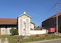
 Mairie with bell tower in Plainemont |
||

Plainemont is a municipality in the French department of Haute-Saône in the region Bourgogne Franche-Comté .
geography
Plainemont is located at an altitude of 300 m above sea level, six kilometers southwest of Saint-Loup-sur-Semouse and about 26 kilometers north of the city of Vesoul (as the crow flies). The village extends in the northern part of the department, in a panoramic position on a hill between the valleys of Planey in the west and Semouse in the east.
The 3.30 km² large municipal area covers a section in the gently undulating landscape north of the Lanterne valley plain . The central part of the area is taken up by the ridge of Plainemont, which runs in a north-south direction. The highest point of Plainemont is reached in the area of the village at 303 m. In geological and tectonic terms, the ridge consists of shell limestone from the Middle Triassic .
The hill is flanked by the alluvial lowlands of two rivers: in the east by the Semouse, in the west by the Planey, which flows into the former at the southernmost point of the municipality. The valley plains are on average 230 m and are approximately one kilometer wide. The Semouse valley in particular is forested ( Bois d'en Bas , Bois d'en Haut ).
Neighboring municipalities of Plainemont are La Pisseure in the north, Ainvelle in the east, Briaucourt in the south and Dampierre-lès-Conflans and Jasney in the west.
history
In the Middle Ages, Plainemont was part of the Free County of Burgundy and in that part of the Bailliage d'Amont area . The Clairefontaine monastery had ruled locally since 1159. Together with Franche-Comté , the place finally came to France with the Peace of Nijmegen in 1678.
Attractions
Among the sights of the place are the stone cross, which is dated to 1608, and the monument aux morts.
Stone cross
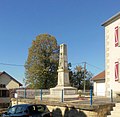
Monument aux morts


population
| Population development | |
|---|---|
| year | Residents |
| 1962 | 42 |
| 1968 | 38 |
| 1975 | 38 |
| 1982 | 49 |
| 1990 | 61 |
| 1999 | 53 |
| 2006 | 56 |
| 2015 | 71 |
With 68 inhabitants (January 1, 2017) Plainemont is one of the smallest municipalities in the Haute-Saône department. After the population had decreased significantly in the first half of the 20th century (109 people were still counted in 1891), a slight population growth has been recorded again since the mid-1970s.
Economy and Infrastructure
Plainemont is still a predominantly agricultural (arable, fruit growing and cattle breeding) and forestry village. Outside of the primary sector there are few jobs in town. Some workers are therefore commuters who work in the larger towns in the area.
The village is away from the major thoroughfares. The main access is from the departmental road that leads from Conflans-sur-Lanterne to Vauvillers . Another road connection is with La Pisseure .