Vy-lès-Lure
| Vy-lès-Lure | ||
|---|---|---|

|
|
|
| region | Bourgogne-Franche-Comté | |
| Department | Haute-Saône | |
| Arrondissement | Lure | |
| Canton | Lure-2 | |
| Community association | Pays de Lure | |
| Coordinates | 47 ° 39 ′ N , 6 ° 27 ′ E | |
| height | 275-359 m | |
| surface | 16 km 2 | |
| Residents | 676 (January 1, 2017) | |
| Population density | 42 inhabitants / km 2 | |
| Post Code | 70200 | |
| INSEE code | 70581 | |
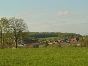
 View of Vy-lès-Lure |
||
Vy-lès-Lure is a commune in the French department of Haute-Saône in the region Bourgogne Franche-Comté .
geography
Vy-lès-Lure is located at an altitude of 292 m above sea level, six kilometers southwest of Lure and about 22 kilometers east of the city of Vesoul (as the crow flies). The village extends in the central part of the department, in the basin of the Gros Varale stream, on the southwestern edge of the Lure plain.
The area of the 16.00 km² large municipal area includes a section of the plain of Lure. The central part of the area is occupied by the Vy basin, which is drained by the Gros Varale to the southeast to the Ognon . The hollow is flanked by plateau-like hills, which are an average of 300 m and are mainly used for agriculture. The arable and meadow land is bordered by a forest belt: in the south the Bois des Grandes Lochères and the Bois de Sansbois , in the east the Bois de Talère . The latter leads over to the alluvial lowland of the Ognon and its tributary Reigne, which mark the eastern boundary of the municipality.
Towards the northwest and north, the terrain rises slightly to the forest heights of Bois du Fays and Bois du Roi , where the highest point of Vy-lès-Lure is reached at 359 m. In geological and tectonic terms, the area is mainly composed of alternating layers of sandy-marl and calcareous sediments that were deposited during the Lias ( Lower Jurassic ). Shell limestone from the Middle Triassic also emerges in the Bois du Roi . To the north, the community area extends into the partly swampy valley of the Razou on the edge of the Lure plain.
The hamlet of La Grange-du-Vau (295 m) in a hollow south of the Razou lowland belongs to Vy-lès-Lure . Neighboring municipalities of Vy-lès-Lure are Amblans-et-Velotte and Magny-Vernois in the north, Vouhenans in the east, Les Aynans and Arpenans in the south and Mollans in the west.
history
Vy is mentioned in a document under the names Vyt , Vile and Vis . In the Middle Ages, the village belonged to the Free County of Burgundy and in that part of the Bailliage d'Amont . It formed its own rule. The existence of the local aristocratic family Vyt has been documented since the early 12th century, and did not go out until 1697. In 1346 the place was set on fire by the Lords of Faucogney. The Grange de Vau was initially owned by the Templars of Sales-Montseugny, later it belonged to the hospitallers . Together with Franche-Comté , Vy finally came to France with the Peace of Nijmegen in 1678. Today, Vy-lès-Lure is a member of the Communauté de communes du Pays de Lure, which comprises 22 localities .
Attractions
The village church of Vy-lès-Lure was largely rebuilt in the 18th and 19th centuries, the choir is from the previous building from the 16th century. Other sights include the Jardin à la française park and a 19th century lavoir that was once used as a wash house and cattle trough.
population
| Population development | |
|---|---|
| year | Residents |
| 1962 | 501 |
| 1968 | 514 |
| 1975 | 437 |
| 1982 | 514 |
| 1990 | 544 |
| 1999 | 555 |
| 2006 | 589 |
With 676 inhabitants (January 1, 2017), Vy-lès-Lure is one of the smaller municipalities in the Haute-Saône department. After the population had decreased significantly in the first half of the 20th century (891 people were still counted in 1881), slight population growth has been recorded again since the mid-1970s.
Economy and Infrastructure
Until well into the 20th century, Vy-lès-Lure was primarily a village characterized by agriculture (arable farming, fruit growing and cattle breeding) and forestry. The hydropower of Ognon and Reigne was previously used to operate mills (Moulin de Petenieuf, Moulin Blanc). Today there are various small and medium-sized businesses. The most important company is a telecommunications company. The electrical engineering, horticulture and wood processing industries are also represented. In the last few decades the village has transformed into a residential community. Many workers are therefore commuters who work in the larger towns in the area.
The village is located off the major thoroughfares on a department road that leads from Lure to Villersexel . Other road links exist with Mollans and Les Aynans. The railway line from Lure to Villersexel ran through the area and will be reactivated when the Rhin-Rhône TGV line is being built.
