Faymont
| Faymont | ||
|---|---|---|
|
|
||
| region | Bourgogne-Franche-Comté | |
| Department | Haute-Saône | |
| Arrondissement | Lure | |
| Canton | Lure-2 | |
| Community association | Pays de Lure | |
| Coordinates | 47 ° 37 ' N , 6 ° 36' E | |
| height | 295-451 m | |
| surface | 7.99 km 2 | |
| Residents | 262 (January 1, 2017) | |
| Population density | 33 inhabitants / km 2 | |
| Post Code | 70200 | |
| INSEE code | 70229 | |

|
||
Faymont is a municipality in the French department of Haute-Saône in the region Bourgogne Franche-Comté .
geography
Faymont is located at an altitude of 395 m above sea level, eleven kilometers southeast of Lure and about 19 kilometers northwest of the city of Montbéliard (as the crow flies). The village extends in the southern foothills of the Vosges , on a plateau in a cleared island in the hill country between the Bois de Granges and the Chérimont .
The area of the 7.99 km² municipal area covers a section in the southern Vosges foothills. The central part of the area is occupied by a plateau inclined slightly to the west, which is an average of 400 m and is made of red sandstone . It is mainly made up of arable and meadow land. This plateau is delimited by valley cuts in the south and north: in the north, the border runs along the Ruisseau de Courmont , while its left tributary, the Ruisseau des Prés Meuniers , drains the southern part. This subdivides the densely forested hilly landscape of the Bois de Granges with its side streams . The highest peaks include the Mont Lambert (421 m) and the Côte des Chênes (451) in the far east.
Faymont's neighboring communities are Lomont in the north, Courmont in the east, Saulnot and Granges-le-Bourg in the south and Mignavillers in the west.
history
Faymont is first mentioned in a document in 1279. The place name is derived from the Latin word fagus (beech) and mont (mountain). In the Middle Ages the village belonged to the Granges rule. During the Thirty Years War the place was largely destroyed. Together with Franche-Comté , Faymont finally came to France with the Peace of Nijmegen in 1678. A change of area occurred in 1808 when the previously independent municipality of Vacheresse was merged with Faymont. In 1923, however, Vacheresse, which formed an exclave , was separated again and merged with Moffans . Today Faymont is a member of the community association Communauté de communes du Pays de Lure, which encompasses 22 villages .
Attractions
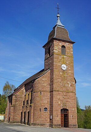
The village church of Saint-Nicolas was built in 1782.
population
| Population development | |
|---|---|
| year | Residents |
| 1962 | 231 |
| 1968 | 223 |
| 1975 | 231 |
| 1982 | 249 |
| 1990 | 243 |
| 1999 | 245 |
With 262 inhabitants (January 1, 2017) Faymont is one of the small communities in the Haute-Saône department. After the population had decreased significantly in the first half of the 20th century (453 people were still counted in 1886), only minor fluctuations have been recorded since the beginning of the 1960s.
Economy and Infrastructure
Until well into the 20th century, Faymont was a village dominated by agriculture (arable farming, fruit growing and cattle breeding) and forestry. The hydropower of the Ruisseau des Prés Meuniers was previously used to operate several mills and a foundry. Today there are some local small businesses. In the meantime, the village has also turned into a residential community. Many employed people are therefore commuters who work in the larger towns in the Lure region and in the Belfort-Montbéliard agglomeration.
The village is located away from the major thoroughfares on a departmental road that leads from Lomont to La Vergenne.
