
Concrete court lès bread
| Concrete court lès bread | ||
|---|---|---|
|
||
| region | Bourgogne-Franche-Comté | |
| Department | Haute-Saône | |
| Arrondissement | Lure | |
| Canton | Lure-1 | |
| Community association | Triangle Vert | |
| Coordinates | 47 ° 45 ′ N , 6 ° 21 ′ E | |
| height | 272-437 m | |
| surface | 3.07 km 2 | |
| Residents | 122 (January 1, 2017) | |
| Population density | 40 inhabitants / km 2 | |
| Post Code | 70300 | |
| INSEE code | 70067 | |
 Mairie Betoncourt-lès-Brotte |
||

Betoncourt-lès-Brotte is a municipality in the French department of Haute-Saône in the region Bourgogne Franche-Comté .
geography

Betoncourt-lès-Brotte is located at an altitude of 285 m above sea level, nine kilometers south-southwest of Luxeuil-les-Bains and about 19 kilometers northeast of the city of Vesoul (as the crow flies). The village extends in the northern part of the department, in a valley south of the Luxeuil plain, at the northern foot of the forest heights of Mont d'Ahie and Grand Bois de Genevrey .
The area of the municipal area of 3.07 km² covers a section of the undulating landscape between the plains of Luxeuil in the northeast and the Vesoul basin in the southwest. The main part of the area is taken up by the valley basin of Betoncourt. It opens to the north to the level of Luxeuil and is drained by the Ru du Bas to the Lanterne . The valley basin lies at an average of 280 m and is used for agriculture. To the west, south and east a step leads over to the adjacent plateaus. In the east there is the Mont d'Ahie , in the south the Grand Bois de Genevrey , on whose plateau at 437 m the highest elevation of Betoncourt-lès-Brotte is reached, and in the west the height of the Chaudron . From a geological and tectonic point of view, these heights consist of alternating layers of calcareous and sandy-marly sediments that were deposited during the Lias ( Lower Jurassic ). Shell limestone from the Middle Triassic also appears in various places .
Neighboring municipalities of Betoncourt-lès-Brotte are Brotte-lès-Luxeuil in the north, Ailloncourt in the east and Genevrey in the southwest.
history
In the Middle Ages, Betoncourt belonged to the Free County of Burgundy and in it to the area of the Bailliage d'Amont . The lords of Luxeuil held local rule. Together with Franche-Comté , the village finally came to France with the Peace of Nijmegen in 1678. Today, Betoncourt-lès-Brotte is a member of the community association Communauté de communes du Pays de Saulx, which comprises 17 villages .
Attractions
The attractions of Betoncourt-lès-Brotte count the Mairie (town hall) with a bell tower, a Calvary from the 12th century and the Lavoir from the 19th century that once served as well, wash and livestock watering.

Fountain
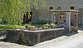
Fountain

Fountain

War memorial


population
| Population development | |
|---|---|
| year | Residents |
| 1962 | 61 |
| 1968 | 64 |
| 1975 | 36 |
| 1982 | 38 |
| 1990 | 48 |
| 1999 | 60 |
| 1999 | 65 |
With 122 inhabitants (January 1, 2017), Betoncourt-lès-Brotte is one of the smallest communities in the Haute-Saône department. After the population had decreased significantly in the first half of the 20th century (173 people were still counted in 1881), population growth has been recorded again since the mid-1970s.
Economy and Infrastructure
Betoncourt-lès-Brotte is still a village dominated by agriculture (arable farming, fruit growing and cattle breeding) and forestry. Outside of the primary sector there are few jobs in town. Some workers are therefore commuters who work in the larger towns in the area.
The village is located off the major thoroughfares, but is easily accessible from the main road N57, which leads from Vesoul to Luxeuil-les-Bains. Further road connections exist with Brotte-lès-Luxeuil and Genevrey.