La Bruyère (Haute-Saône)
| La briar | ||
|---|---|---|

|
|
|
| region | Bourgogne-Franche-Comté | |
| Department | Haute-Saône | |
| Arrondissement | Lure | |
| Canton | Mélisey | |
| Community association | Haute Vallée de l'Ognon | |
| Coordinates | 47 ° 50 ′ N , 6 ° 29 ′ E | |
| height | 309-426 m | |
| surface | 6.32 km 2 | |
| Residents | 218 (January 1, 2017) | |
| Population density | 34 inhabitants / km 2 | |
| Post Code | 70280 | |
| INSEE code | 70103 | |
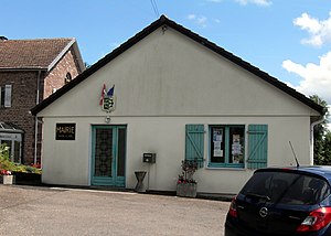
 Mairie La Bruyère |
||
La Bruyère is a municipality in the French department of Haute-Saône in the region Bourgogne Franche-Comté .
geography
La Bruyère is located at an altitude of 357 m above sea level, eight kilometers east of Luxeuil-les-Bains and about 34 kilometers northeast of the city of Vesoul (as the crow flies). The village extends in the northern part of the department, in the southwestern foothills of the Vosges , slightly elevated on the southern edge of the Breuchin valley .
The area of the 6.32 km² municipal area comprises a section of the plateau landscape on the south-western edge of the Vosges, which is criss-crossed by valleys. The northern border runs along the Breuchin, which flows here with several windings through an alluvial lowland to the west. The floodplain lies at an average of 340 m and is around one kilometer wide.
From the course of the river, the community area extends southward over the valley and over a steep slope to the adjacent plateau of the Haut des Sombres . It is made up of crystalline bedrock. At 426 m, the highest point of La Bruyère is reached here. The plateau is bounded in the west by a side valley of the Breuchin. With a narrow tip, the community soil extends further south to the edge of the Luxeuil plain. This part is drained by the Ruisseau du Vay de Brest and its source streams to the west to the Lanterne . It shows a loose structure of meadow and forest. In several places there are ponds that were created for fish farming. The entire municipality is part of the Ballons des Vosges Regional Nature Park .
In addition to the actual village, La Bruyère includes the following settlements:
- La Bouloye (342 m) in the Breuchin floodplain
- Les Piquards (332 m) on the edge of the Luxeuil plain
- Le Bois Joffroy (355 m) on a slightly elevated position east of the Luxeuil plain
Neighboring municipalities of La Bruyère are Amage in the north, La Proiselière-et-Langle in the east, La Corbière and Magnivray in the south and Esboz-Brest and Breuchotte in the west.
history
The place name is derived from the old French word Bruiera and the late Latin name Brugera and means something like undeveloped land or pastureland . In the Middle Ages, La Bruyère belonged to the Free County of Burgundy and in it to the area of the Bailliage d'Amont . Local rule was held by the abbots of the Luxeuil monastery . Together with Franche-Comté , the village finally came to France with the Peace of Nijmegen in 1678. Today La Bruyère is a member of the community association Communauté de communes des Mille Étangs, which comprises 16 villages .
population
| Population development | |
|---|---|
| year | Residents |
| 1962 | 226 |
| 1968 | 202 |
| 1975 | 175 |
| 1982 | 200 |
| 1990 | 205 |
| 1999 | 199 |
| 2006 | 205 |
With 218 inhabitants (January 1, 2017), La Bruyère is one of the small communities in the Haute-Saône department. After the population had decreased significantly in the first half of the 20th century (366 people were still counted in 1881), only relatively minor fluctuations have been recorded since the early 1970s.
Economy and Infrastructure
Until well into the 20th century, La Bruyère was primarily a village characterized by agriculture (arable farming, fruit growing and cattle breeding), forestry and fish farming. The water power of the streams was used to operate mills. Today there are some local small businesses. In the last few decades the village has transformed into a residential community. Many workers are therefore commuters who work in the larger towns in the area.
The village is located off the major thoroughfares on a departmental road that leads from Breuchotte to La Proiselière. Other road links exist with Magnivray, Esboz-Brest and La Corbière.
Personalities
- Albert Mathiez (1874–1932), historian
