Rigny
| Rigny | ||
|---|---|---|

|
|
|
| region | Bourgogne-Franche-Comté | |
| Department | Haute-Saône | |
| Arrondissement | Vesoul | |
| Canton | Dampierre-sur-Salon | |
| Community association | Val de Gray | |
| Coordinates | 47 ° 28 ' N , 5 ° 38' E | |
| height | 189-246 m | |
| surface | 12.72 km 2 | |
| Residents | 595 (January 1, 2017) | |
| Population density | 47 inhabitants / km 2 | |
| Post Code | 70100 | |
| INSEE code | 70446 | |
Rigny is a municipality in the French department of Haute-Saône in the region Bourgogne Franche-Comté .
geography
Rigny is located at an altitude of 194 m above sea level, four kilometers northeast of Gray and about 40 kilometers northwest of the city of Besançon (as the crow flies). The village extends in the west of the department, in the plain of Gray, on the northern edge of the valley of the Saône .
The area of the 12.72 km² municipal area covers a section of the central Saône valley. The southern part of the municipality is occupied by the Saône lowland, which is around three kilometers wide and an average of 190 m. The Saône flows here with several turns through the partly marshy alluvial lowland to the southwest. It is canalised and developed into a waterway; there is a lock at Rigny. The southern border runs partly along the Saône, but also a larger area south of the river to the watercourse of the Eau Blanche belongs to Rigny. To the north, the community area extends over the valley floodplain and a 20 m high step to the adjacent plateau, which is 230 m. It consists of an alternating layer of calcareous and sandy-marl sediments from the Upper Jurassic period . Agricultural use predominates on the plateau, but there are also some forest areas. At 246 m, the highest point of Rigny is reached on a knoll north of the village.
Rigny includes the hamlet of Le Bouchot (193 m) on the north bank of the Saône and the Saint-Laurent farm . Neighboring municipalities of Rigny are Montureux-et-Prantigny in the north, Beaujeu-Saint-Vallier-Pierrejux-et-Quitteur and Saint-Broing in the east, Gray in the south and Arc-lès-Gray and Chargey-lès-Gray in the west.
history
The municipality of Rigny was already populated in prehistoric times. The earliest evidence of man's presence comes from the Magdalenian . Various finds testify to the settlement during the Gallo-Roman period. A Burgundy grave was also discovered.
In the Middle Ages, Rigny belonged to the Free County of Burgundy and in that part of the Bailliage d'Amont . The local rule was initially incumbent on the Lords of Fouvent, before the village passed to the Autrey rule in 1203. In 1311 the villagers were granted freedom rights. As part of the Thirty Years War, Rigny was devastated in 1636 and numerous residents were killed. Together with Franche-Comté , the village finally came to France with the Peace of Nijmegen in 1678. Today Rigny is a member of the communal association Communauté de communes du Val de Gray, which comprises 16 villages .
Attractions
The Saint-Étienne church was rebuilt in 1720. It has rich church furnishings , including the pulpit (17th century), a stucco altar (18th century) and two paintings by Prud'hon (1794).
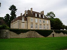
In the place of the former manor house, a new castle was built in the 17th century, which was expanded in the 19th century and now houses a hotel with a restaurant.
In the village square is the covered lavoir (wash house) with an arcade arch , which was built in 1840.
population
| Population development | |
|---|---|
| year | Residents |
| 1962 | 385 |
| 1968 | 475 |
| 1975 | 501 |
| 1982 | 516 |
| 1990 | 529 |
| 1999 | 586 |
With 595 inhabitants (January 1, 2017), Rigny is one of the smaller municipalities in the Haute-Saône department. After the population had decreased significantly in the first half of the 20th century (592 people were counted in 1881), the population has continued to grow steadily since the early 1960s.
Economy and Infrastructure
For a long time, Rigny was primarily a village characterized by agriculture (arable farming, fruit growing and cattle breeding) and fishing. Today there are various local small businesses. In the last few decades the village has transformed into a residential community. Many workers are therefore commuters who work in the larger towns in the area.
The village is located off the major thoroughfares on a department road that leads from Arc-lès-Gray to Beaujeu. Further road connections exist with Chargey-lès-Gray and Montureux.

