Bucey-lès-Gy
| Bucey-lès-Gy | ||
|---|---|---|

|
|
|
| region | Bourgogne-Franche-Comté | |
| Department | Haute-Saône | |
| Arrondissement | Vesoul | |
| Canton | Marnay | |
| Community association | Monts de Gy | |
| Coordinates | 47 ° 25 ' N , 5 ° 51' E | |
| height | 206-406 m | |
| surface | 21.30 km 2 | |
| Residents | 592 (January 1, 2017) | |
| Population density | 28 inhabitants / km 2 | |
| Post Code | 70700 | |
| INSEE code | 70104 | |
| Website | www.bucey-les-gy.com | |
 Bucey-lès-Gy |
||
Bucey-lès-Gy is a municipality in the French department of Haute-Saône in the region Bourgogne Franche-Comté .
geography
Bucey-lès-Gy is located at an altitude of 229 m above sea level, three kilometers northeast of Gy and about 25 kilometers northwest of the city of Besançon (as the crow flies). The village extends in the southwest of the department, at the northwest foot of the heights of the Monts de Gy , at the outlet of the Morthe into the basin of the Saône .
The area of the municipal area of 21.30 km² covers a section of the undulating landscape between the river valleys of Saône and Ognon . The area is naturally divided into two parts. The smaller north-western part is occupied by a basin, a so-called alluvial plain , which averages 210 m. It is drained by the Morte, which in sections marks the northern municipal boundary, to the west to the Saône. The fertile soils are mainly used for agriculture.
To the southeast the terrain gradually rises to the heights of the Monts de Gy. These are subdivided by the valley of the Morte, which rises near Saint-Maurice. The hills Folle (311 m) and Champtourneaux rise above Bucey and offer a beautiful view of the surrounding area. South of the Morte Valley, a large part of the Bois de Plumont ridge (379 m) belongs to Bucey. Further to the south-east, the municipal area extends over the high plateau of the Grand Bois de Bucey , which is partly covered with meadow, but predominantly with forest , in which the highest elevation of Bucey-lès-Gy is reached at 406 m. This plateau shows no surface watercourses because the rainwater seeps into the karstified subsoil. In geological and tectonic terms, the Monts de Gy consist of an alternating layer of calcareous and sandy-marl sediments that were deposited in the Middle and Upper Jurassic and Cretaceous periods . The eastern boundary is marked by the valley cut of the Ruisseau de Poussot , a right tributary of the Ognon.
In addition to the actual village, Bucey-lès-Gy also includes the two hamlets Roche (235 m) in the Morte Valley and Saint-Maurice (290 m) in a basin in the Monts de Gy. Neighboring municipalities of Bucey-lès-Gy are Vellefrey-et-Vellefrange , Vantoux-et-Longevelle and Velleclaire in the north, Oiselay-et-Grachaux and Montboillon in the east, Gézier-et-Fontenelay in the south and Gy in the west.
history
The municipal area of Bucey-lès-Gy was inhabited as early as prehistoric times. Several tumuli date from the Chalcolithic period .
In the Middle Ages, Bucey belonged to the Free County of Burgundy and in it to the area of the Bailliage d'Amont . The Archbishops of Besançon, who resided in Gy, had ruled since 1091. Together with Franche-Comté , Bucey finally came to France with the Peace of Nijmegen in 1678. The village of Saint-Maurice was largely destroyed by German troops in an act of retaliation in 1944. Today Bucey-lès-Gy is a member of the community association Communauté de communes des Monts de Gy, which comprises 20 towns .
Attractions
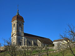
Bucey-lès-Gy has preserved its townscape in the style of a characteristic wine-growing village and has been awarded the label "Petite Cité Comtoise de Caractère". In the old town center, numerous town houses and winegrowers' houses from the 17th to 19th centuries have been preserved. On a hill above the village stands the Saint-Martin church, which originally dates from the 14th century, but was redesigned in the 16th century and from 1760 onwards. The Chapelle du Clos was built in the 18th century. The Mairie (town hall) dates from the time of the Second Empire . The village square was redesigned in 1994 with elements of modern art. Also worth seeing are the lavoir (19th century) and the Calvaire in Roche from the 17th century.
population
With 592 inhabitants (January 1, 2017), Bucey-lès-Gy is one of the smaller communities in the Haute-Saône department. The highest number of inhabitants was registered in the period around 1840, when Bucey-lès-Gy counted almost 1,800 people. Subsequently, the population decreased continuously (in 1881 still 1366 inhabitants). A stabilization in the range between 550 and 650 people occurred from 1930. Since then, only minor fluctuations have been recorded.
| Population development | ||||||||
|---|---|---|---|---|---|---|---|---|
| year | 1962 | 1968 | 1975 | 1982 | 1990 | 1999 | 2009 | 2017 |
| Residents | 658 | 623 | 572 | 581 | 583 | 593 | 655 | 592 |
Economy and Infrastructure
For a long time, Bucey-lès-Gy was primarily a village characterized by agriculture (arable farming, viticulture and cattle breeding) and forestry. Today there are various small and medium-sized businesses. The most important employer is a company in the heating technology sector (Franche-Comté Chauffage). In the last few decades the village has transformed into a residential community. Many workers are therefore commuters who work in the larger towns in the area.
The village is well developed in terms of traffic. It is located on the main road D474, which leads from Gray via Gy to Vesoul . There are other road connections with Vellefrey and Vantoux.

