Valay
| Valay | ||
|---|---|---|
|
|
||
| region | Bourgogne-Franche-Comté | |
| Department | Haute-Saône | |
| Arrondissement | Vesoul | |
| Canton | Marnay | |
| Community association | Val de Gray | |
| Coordinates | 47 ° 20 ' N , 5 ° 38' E | |
| height | 206-266 m | |
| surface | 17.40 km 2 | |
| Residents | 693 (January 1, 2017) | |
| Population density | 40 inhabitants / km 2 | |
| Post Code | 70140 | |
| INSEE code | 70514 | |
Valay is a municipality in the French department of Haute-Saône in the region Bourgogne Franche-Comté .
geography
Valay is located at an altitude of 216 m above sea level, nine kilometers northeast of Pesmes and about 31 kilometers west-northwest of the city of Besançon (as the crow flies). The village extends in the south of the department, east of the Saône plain in the headwaters of the Résie stream.
The area of the 17.40 km² municipal area comprises a section of the gently undulating landscape between the valley plains of Ognon in the south and Saône in the north. Valay is located in a basin in which the Résie rises and provides drainage to the west to the Ognon. The valley is flanked on both sides by a plateau at an average of 230 m. It is made up of Tertiary and Cretaceous sediments and is mainly used for agriculture. The large cleared island of Valay is bordered by extensive forests: to the west by the Bois de la Fresse , to the north by the Bois d'Arsans , to the east by the Bois de la Féole and to the south by the Bois de Riand . The highest point of Valay is reached here at 266 m. The municipal area extends with a narrow tip to the southwest over the lowland of the Ruisseau de Sainte-Cécile into the Gros Bois .
Neighboring municipalities of Valay are Lieucourt , Arsans , Champtonnay and Venère in the north, Chancey in the east, Motey visits , Montagney , Chaumercenne and La Résie-Saint-Martin in the south and Pesmes , Chevigney and Vadans in the west.
history
Remains of two Roman country estates indicate that the municipality of Valay was settled very early. In the Middle Ages, Valay belonged to the Free County of Burgundy and in it to the area of the Bailliage d'Amont . The local rule was held by the Lords of Pesmes, who left part of the area for the foundation of the Corneux monastery. Together with Franche-Comté , Valay finally came to France with the Peace of Nijmegen in 1678. In the 18th and 19th centuries, the ironworks of Grand-Valay ensured an economic boom in the town, which led to a high population of around 1200 people (around 1870). With the inauguration of the railway line from Marnay to Gray in 1910, the village was connected to the French railway network. However, the line was stopped again. Today Valay is a member of the community association Communauté de communes du Val de Pesmes, which comprises 18 villages .
Attractions
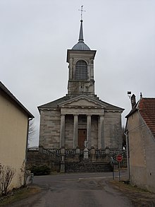
The three-nave village church of Valay was rebuilt in the 18th century and has a rich interior . Only a few remains are visible of the former Sainte-Cécile hermitage.
A mansion dates from the 18th century. From the former iron works, workshops, a blast furnace and workers' houses have been preserved.
population
| 1962 | 1968 | 1975 | 1982 | 1990 | 1999 | 2008 |
|---|---|---|---|---|---|---|
| 548 | 486 | 506 | 456 | 436 | 512 | 664 |
With 685 inhabitants (2009) Valay is one of the smaller communities in the Haute-Saône department. After the population had decreased significantly in the first half of the 20th century (1005 people were still counted in 1881), population growth has been recorded again since the beginning of the 1990s.
Economy and Infrastructure
For a long time, Valay was primarily a village characterized by agriculture (arable farming, fruit growing and cattle breeding) and forestry. The iron industry saw its gradual decline at the beginning of the 20th century. Today there are various local small-scale businesses, including construction, plastics processing and precision engineering. In the last few decades the village has transformed into a residential community. Many workers are therefore commuters who work in the larger towns in the area.
The village is off the major thoroughfares on a department road that leads from Gray to Ougney . The closest connection to the A36 motorway is around 20 km away. Other road connections exist with Vadans, Chevigney, La Résie-Saint-Martin, Chancey, Venère and Lieucourt.
Web links
Individual evidence
- ↑ Valay on the INSEE site ( page no longer available , search in web archives ) Info: The link was automatically marked as defective. Please check the link according to the instructions and then remove this notice.
- ↑ Valay: Population 2009 (INSEE)

