
Varogne
| Varogne | ||
|---|---|---|
|
||
| region | Bourgogne-Franche-Comté | |
| Department | Haute-Saône | |
| Arrondissement | Vesoul | |
| Canton | Vesoul-2 | |
| Community association | Terres de Saône | |
| Coordinates | 47 ° 43 ' N , 6 ° 12' E | |
| height | 243-330 m | |
| surface | 4.41 km 2 | |
| Residents | 146 (January 1, 2017) | |
| Population density | 33 inhabitants / km 2 | |
| Post Code | 70240 | |
| INSEE code | 70522 | |
 Town view from the south |
||

Varogne is a municipality in the French department of Haute-Saône in the region Bourgogne Franche-Comté .
geography
Varogne is located at an altitude of 262 m above sea level, about eleven kilometers north-northeast of the city of Vesoul (as the crow flies). The village extends in the central part of the department, in the north-east of the Vesoul basin, on a slope sloping slightly to the south above the valley of the Ruisseau de Vienne.
The area of the 4.41 km² municipal area includes a section in the area of the Vesoul basin. The southern part of the area is taken up by the basin of the Ruisseau de Vienne , which provides drainage to the southwest to the Bâtard . To the north of the basin is the Varogne plateau, which averages 270 m. It is mainly used for agriculture and leads east to the Saulx basin. The eastern boundary runs in the area of the Haut de Chenevières (296 m). To the north, the municipality extends into the forests of the Bois de Revreuge and the Bois de la Bataille . At 330 m, the highest point in Varogne is reached here. From a geological and tectonic point of view, this section of the terrain consists of alternating layers of sandy-marly and calcareous sediments that were deposited during the Lias ( Lower Jurassic ).
Neurey-en-Vaux in the north, Vilory in the east, Vellefrie and Flagy in the south and Le Val-Saint-Éloi in the west are neighboring municipalities of Varogne .
history
In the Middle Ages, Varogne belonged to the Free County of Burgundy and in that part of the Bailliage d'Amont . Together with Franche-Comté , the village finally came to France with the Peace of Nijmegen in 1678. Today Varogne is a member of the Terres de Saône municipal association, which comprises six localities .
Attractions
The village church of Saint-Barthélemy in Varogne was rebuilt in the 18th century and has an imperial-style tower. The Fontaine Voyo source also dates from this period.
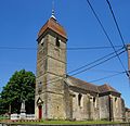
Saint Barthélemy Church
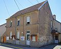
Town hall and school building

crossroads

public scales


population
| Population development | |
|---|---|
| year | Residents |
| 1962 | 108 |
| 1968 | 98 |
| 1975 | 120 |
| 1982 | 136 |
| 1990 | 131 |
| 1999 | 115 |
| 2006 | 135 |
With 146 inhabitants (January 1, 2017), Varogne is one of the small communities in the Haute-Saône department. After the population had decreased significantly in the first half of the 20th century (252 people were still counted in 1881), only relatively minor fluctuations have been recorded since the beginning of the 1960s.
Economy and Infrastructure
Varogne is still a predominantly agricultural (arable, fruit growing and cattle breeding) and forestry village. Outside of the primary sector there are few jobs in town. Some workers are therefore commuters who work in the larger towns in the area.
The place is off the major thoroughfares on a department road that leads from Vesoul to Saint-Loup-sur-Semouse . There are other road links with Vellefrie and Vilory.