Baignes
| Baignes | ||
|---|---|---|
|
|
||
| region | Bourgogne-Franche-Comté | |
| Department | Haute-Saône | |
| Arrondissement | Vesoul | |
| Canton |
Scey-sur-Saône- et-Saint-Albin |
|
| Community association | Combes | |
| Coordinates | 47 ° 35 ' N , 6 ° 3' E | |
| height | 219-378 m | |
| surface | 2.87 km 2 | |
| Residents | 104 (January 1, 2017) | |
| Population density | 36 inhabitants / km 2 | |
| Post Code | 70000 | |
| INSEE code | 70047 | |
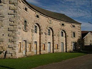
 Building of the former Baignes ironworks |
||
Baignes is a municipality in the French department of Haute-Saône in the region Bourgogne Franche-Comté .
geography
Baignes is located at an altitude of 222 m above sea level, about nine kilometers southwest of Vesoul (as the crow flies). The village extends in the central part of the department, in a basin at the source of the Baignotte, at the western foot of the heights that rise between the river valleys of Saône and Ognon .
The area of the 2.87 km² municipal area includes a section in the area of the upper Saône basin. The central part of the area is taken up by the Baignotte basin, which rises here and provides drainage to the north to the Durgeon . To the west and south-west, the communal soil extends to the plateau of the upper Saône basin, which lies at an average of 250 m. It is used for agriculture, but also shows some forest areas. The municipal area extends with a narrow strip to the southeast over a wooded slope to the adjacent ridge of the Côte d'Andelarre , which belongs to the hilly area between the Saône and Ognon. It consists of limestone sediments from the middle Jurassic period . At 378 m, the highest point in Baignes is reached on the summit of the Bois Monsieur .
Neighboring municipalities of Baignes are Clans in the north, Velle-le-Châtel in the east, Mailley-et-Chazelot and Rosey in the south and Raze in the west.
history
The place name of Baignes goes back to a spa at the Source de la Font that has been used since ancient times . In the Middle Ages, the village belonged to the Free County of Burgundy and in that part of the Bailliage d'Amont . The local noble family von Baignes has been mentioned since 1390. Together with Franche-Comté , Baignes finally came to France with the Peace of Nijmegen in 1678. In the 16th century a forge and a blast furnace were built that used the water power of the Baignotte. The ironworks was converted into a foundry in 1890, which ceased operations in 1960. Today Baignes is a member of the community association Communauté de communes des Combes, which encompasses 22 villages .
Attractions
The facilities of the former ironworks in the style of architecture from the age of the industrial revolution in the late 18th century, including warehouses, workers' houses, horse stables, an orangery and a pigeon house are worth seeing. The complex is classified as a monument historique .
population
| Population development | |
|---|---|
| year | Residents |
| 1962 | 93 |
| 1968 | 113 |
| 1975 | 91 |
| 1982 | 96 |
| 1990 | 112 |
| 1999 | 93 |
With 99 inhabitants (2005), Baignes is one of the smallest municipalities in the Haute-Saône department. After the population had decreased significantly in the first half of the 20th century (292 people were counted in 1886), only slight fluctuations have been recorded since the early 1960s.
Economy and Infrastructure
Baignes has been shaped by the ironworks and the subsequent foundry since the beginning of the industrial age. Today there are some farms and individual local small businesses. In the last few decades the village has transformed into a residential community. Many workers are therefore commuters who go to work in the Vesoul agglomeration.
The place is off the major thoroughfares on a department road that leads from Velle-le-Châtel to Rosey.
