
Cubry-lès-Faverney
| Cubry-lès-Faverney | ||
|---|---|---|

|
|
|
| region | Bourgogne-Franche-Comté | |
| Department | Haute-Saône | |
| Arrondissement | Vesoul | |
| Canton | Port-sur-Saône | |
| Community association | Terres de Saône | |
| Coordinates | 47 ° 49 ' N , 6 ° 8' E | |
| height | 222-305 m | |
| surface | 5.59 km 2 | |
| Residents | 178 (January 1, 2017) | |
| Population density | 32 inhabitants / km 2 | |
| Post Code | 70160 | |
| INSEE code | 70190 | |
 Mairie Cubry-lès-Faverney |
||

Cubry-lès-Faverney is a commune in the French department of Haute-Saône in the region Bourgogne Franche-Comté .
geography
Cubry-lès-Faverney is located at an altitude of 233 m above sea level, five kilometers north-northeast of Faverney and about 21 kilometers north of the city of Vesoul (as the crow flies). The village extends in the northern part of the department, in the hollow of the Ruisseau des Canes, on the northern edge of the wide valley floor of the Lanterne .
The area of the 5.59 km² municipal area comprises a section in the gently undulating landscape north of the Lanterne valley plain. From north to south the area is crossed by the valley of the Ruisseau des Canes , which is dammed into several ponds northwest of the village. The alluvial low lies at an average of 230 m and opens to the south to the level of the Lanterne. Agricultural use prevails here. The southern border runs along the Bois de Revreuge .
The valley is flanked in the west by the Haut de Faux (255 m) and in the east by the Bois de Cubry (257 m). To the north, the community area extends over the gently sloping terrain into the forests of Grand Bois , Bois de la Chapelle and up to the southern roof of the Fougermont . Here, at 305 m, the highest point in Cubry-lès-Faverney is reached. From a geological and tectonic point of view, the area consists of alternating layers of sandy-marl and calcareous sediments that were deposited during the Lias ( Lower Jurassic ). Shell limestone from the Middle Triassic also appears in some places .
Neighboring communities of Cubry-lès-Faverney are Saint-Rémy-en-Comté in the north, Bourguignon-lès-Conflans in the east, Mersuay in the south and Menoux in the west.
history
Cubry is first mentioned in a document in 1276. In the Middle Ages, the village belonged to the Free County of Burgundy and within it to the area of the Bailliage d'Amont . Faverney monastery held local rule. Together with Franche-Comté , the place finally came to France with the Peace of Nijmegen in 1678. Today Cubry-lès-Faverney is a member of the communal association Communauté de communes de la Saône Jolie, which comprises 16 localities .
Attractions
The Nativité de Saint-Jean-Baptiste church was rebuilt in the 18th century and restored in 1978. The remarkable furnishings include the statues of Mary and John the Baptist (17th century), furniture and paintings and a richly carved altar (18th century) as well as contemporary stained glass windows.
The covered lavoir on Ruisseau des Canes, which once served as a wash house and cattle trough, is built with a road bridge.
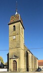
Nativité de Saint-Jean-Baptiste church


population
| Population development | |
|---|---|
| year | Residents |
| 1962 | 107 |
| 1968 | 115 |
| 1975 | 121 |
| 1982 | 128 |
| 1990 | 131 |
| 1999 | 114 |
| 2006 | 97 |
With 178 inhabitants (January 1, 2017) Cubry-lès-Faverney is one of the smallest communes in the Haute-Saône department. After the population had decreased significantly in the first half of the 20th century (230 people were still counted in 1881), only relatively minor fluctuations have been recorded since the beginning of the 1950s.
Economy and Infrastructure
Until well into the 20th century, Cubry-lès-Faverney was primarily a village characterized by agriculture (arable farming, fruit growing and cattle breeding) and forestry. Today there are some local small businesses, mainly in the wood processing and agricultural machinery industries. In the last few decades the village has transformed into a residential community. Many workers are therefore commuters who work in the larger towns in the area.
The village is located off the major thoroughfares on a departmental road that leads from Menoux to Bourguignon-lès-Conflans. Further road connections exist with Mersuay and Anchenoncourt.