
Provenchère (Haute-Saône)
| Provenchère | ||
|---|---|---|

|
|
|
| region | Bourgogne-Franche-Comté | |
| Department | Haute-Saône | |
| Arrondissement | Vesoul | |
| Canton | Port-sur-Saône | |
| Community association | Terres de Saône | |
| Coordinates | 47 ° 43 ' N , 6 ° 8' E | |
| height | 255-364 m | |
| surface | 5.82 km 2 | |
| Residents | 260 (January 1, 2017) | |
| Population density | 45 inhabitants / km 2 | |
| Post Code | 70170 | |
| INSEE code | 70426 | |
 Mairie Provenchère |
||

Provenchère is a municipality in the French department of Haute-Saône in the region Bourgogne Franche-Comté .
geography
Provenchère is located at an altitude of 278 m above sea level, about twelve kilometers north-northwest of the city of Vesoul (as the crow flies). The village extends in the central part of the department, in the valley of the Scyotte, east of the Saône valley, at the west foot of the heights of the Bois de Breurey.
The area of the 5.82 km² municipal area includes a section in the area of the undulating landscape east of the Saône valley. The central part of the area is occupied by the valley basin of the Scyotte, which rises above the village and provides drainage to the southwest to the Saône. The lowland is approximately one kilometer wide and averages 270 m. The valley is flanked on its west side by a plateau that leads to the Saône valley. Agricultural use predominates here. In the north and east, the hollow is surrounded by the wooded heights of the Bois de Breurey . The highest point of Provenchère is reached here at 364 m. From a geological and tectonic point of view, the terrain consists of alternating layers of sandy-marly and calcareous sediments from the lower Jurassic period (Lias). Shell limestone also emerges in the Bois de Breurey .
Neighboring municipalities of Provenchère are Fleurey-lès-Faverney in the north, Breurey-lès-Faverney and Auxon in the east, Bougnon in the south and Villers-sur-Port in the west.
history
In the Middle Ages, Provenchère belonged to the Free County of Burgundy and in it to the area of the Bailliage d'Amont . The village was donated to the Faverney monastery in 1276. A minorite convent was founded here in the 15th century . Together with Franche-Comté , Provenchère finally came to France with the Peace of Nijmegen in 1678. Today Provenchère is a member of the Terres de Saône municipal association .
Attractions
The Saint-Valbert Church was built in 1759 in the classical style and has furniture, paneling in the Louis XV style and paintings from the 18th century. Next to the church is a calvary , which is dated to 1763.
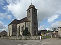
Saint-Valbert Church

Ruins of the monastery in Provenchère
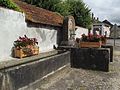
Fontaine de la cure


Convent buildings from the 18th century and ruins of the chapel have been preserved from the former Minorite monastery. The Mairie (municipal administration) is located in a former manor house.
population
| Population development | |
|---|---|
| year | Residents |
| 1962 | 161 |
| 1968 | 170 |
| 1975 | 141 |
| 1982 | 198 |
| 1990 | 216 |
| 1999 | 207 |
| 2006 | 261 |
With 260 inhabitants (January 1, 2017) Provenchère is one of the small communities in the Haute-Saône department. After the population had decreased significantly in the first half of the 20th century (326 people were counted in 1891), strong population growth has been recorded again since the mid-1970s.
Economy and Infrastructure
Until well into the 20th century, Provenchère was mainly a village characterized by agriculture (arable farming, fruit growing and cattle breeding) and forestry. Today there are various local small-scale businesses, especially in the wood processing industry. In the last few decades the village has transformed into a residential community. Many workers are therefore commuters who go to work in the Vesoul agglomeration.
The village is located off the major thoroughfares on a departmental road that leads from Port-sur-Saône to Breurey-lès-Faverney. Another road connection is with Bougnon.