
Ormoy (Haute-Saône)
| Ormoy | ||
|---|---|---|
|
||
| region | Bourgogne-Franche-Comté | |
| Department | Haute-Saône | |
| Arrondissement | Vesoul | |
| Canton | Jussey | |
| Community association | Hauts du Val de Saône | |
| Coordinates | 47 ° 53 ' N , 5 ° 59' E | |
| height | 216–343 m | |
| surface | 19.54 km 2 | |
| Residents | 215 (January 1, 2017) | |
| Population density | 11 inhabitants / km 2 | |
| Post Code | 70500 | |
| INSEE code | 70399 | |
,_Mairie.jpg) Mairie Ormoy |
||

Ormoy is a commune in the French department of Haute-Saône in the region Bourgogne Franche-Comté .
geography
Ormoy is located at an altitude of 230 m above sea level, nine kilometers northeast of Jussey and about 34 kilometers north-northwest of the city of Vesoul (as the crow flies). The village extends in the north-western part of the department, slightly elevated on the eastern edge of the Saône valley , between the heights of Bois Saint-Julien in the north-west and Bois Lajux in the south.
The area of the 19.54 km² municipal area includes a section in the area of the upper Saône valley. The western border mostly runs along the Saône, which flows here through an alluvial lowland around 1.5 kilometers wide to the southwest. The floodplain lies at an average of 218 m and is mainly used for agriculture. The river is canalised and turned into a waterway; there is a lock mechanism in the Ormoy section. Remnants of the old barrel with several small loops are present.
From the course of the river, the municipal area extends eastward over the valley floodplain to the adjacent, plateau-like landscape, which is divided by troughs of short side streams of the Saône. In the south of the village rises the wooded high plateau des Bois Lajux , on which the highest elevation of Ormoy is reached at 343 m. To the east, the community soil extends into the extensive forest of the Bois Lessus (333 m). From a geological and tectonic point of view, the terrain consists of alternating layers of sandy-marl and calcareous sediments, which were mainly deposited during the Lias ( Lower Jurassic ). In some places shell limestone from the Triassic comes to light.
Neighboring municipalities of Ormoy are Ranzevelle , Corre and Demangevelle in the north, Hurecourt , Polaincourt-et-Clairefontaine and Saponcourt in the east, Magny-lès-Jussey and Cendrecourt in the south and Betaucourt and Aisey-et-Richecourt in the west.
history
Remains of a Merovingian burial ground point to an early settlement of the area. Ormoy was first mentioned in a document in 1150. In the Middle Ages, the village belonged to the Free County of Burgundy and in it to the area of the Bailliage d'Amont . It formed a fiefdom that had belonged to the Lords of Jonvelle since 1263 . Together with Franche-Comté , Ormoy finally came to France with the Peace of Nijmegen in 1678. Today Ormoy is a member of the communal association Communauté de communes du Pays Jusséen, which comprises 17 villages .
Attractions
The village church of the Birth of Mary ( Église de la Nativité-de-Notre-Dame ) in Ormoy was built in the 18th century and redesigned in the 19th century. A former mansion dates from the 16th century. The town center is characterized by various houses from the 18th century, which show the traditional style of the Haute-Saône. In the village square there is a round fountain with the statue of Marianne.
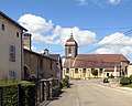
Church of the Birth of Mary
Lavoir in Ormoy

Round fountain with the statue of Marianne


population
| Population development | |
|---|---|
| year | Residents |
| 1962 | 312 |
| 1968 | 265 |
| 1975 | 226 |
| 1982 | 218 |
| 1990 | 188 |
| 1999 | 228 |
| 2006 | 234 |
With 215 inhabitants (January 1, 2017) Ormoy is one of the small communities in the Haute-Saône department. After the population had decreased significantly in the first half of the 20th century (1000 people were still counted in 1881), slight population growth has been recorded since the beginning of the 1990s.
Personalities
- Jacques Ferrand (1746–1804), infantry general
Economy and Infrastructure
Until well into the 20th century, Ormoy was primarily a village characterized by agriculture (arable farming, viticulture and cattle breeding) and forestry. The Saône's hydropower was previously used to power mills. Today there are some local small businesses. In the last few decades the village has transformed into a residential community. Many workers are therefore commuters who work in the larger towns in the area.
The village is located off the major thoroughfares on a department road that leads from Cendrecourt to Corre. Further road connections exist with Saponcourt and Richecourt.