
Villars-le-Pautel
| Villars-le-Pautel | ||
|---|---|---|
|
||
| region | Bourgogne-Franche-Comté | |
| Department | Haute-Saône | |
| Arrondissement | Vesoul | |
| Canton | Jussey | |
| Community association | Hauts du Val de Saône | |
| Coordinates | 47 ° 54 ' N , 5 ° 56' E | |
| height | 220–342 m | |
| surface | 12.18 km 2 | |
| Residents | 193 (January 1, 2017) | |
| Population density | 16 inhabitants / km 2 | |
| Post Code | 70500 | |
| INSEE code | 70554 | |
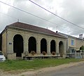
 Mairie Villars-le-Pautel |
||

Villars-le-Pautel is a French commune in the department of Haute-Saône in the region Bourgogne Franche-Comté .
geography
Villars-le-Pautel is located at an altitude of 240 m above sea level, eight kilometers north-northeast of Jussey and about 35 kilometers north-northwest of the city of Vesoul (as the crow flies). The village extends in the extreme northwest of the department, west of the Saône valley in the valley of the Bazeuille, on a flat area at the southern foot of the hills of the Bois Saint-Julien .
The area of the 12.18 km² municipal area includes a section in the area of the upper Saône valley. The central part of the area is occupied by the basin of the Ruisseau de la Bazeuille , which provides drainage to the southeast to the Saône. The valley low lies on average at 230 m and has a width of about one kilometer. Agricultural use prevails here.
The basin is flanked in the west by the Bois des Cornées , in the northwest by the Haut du Pleuvre and in the north by the heights of the Bois Saint-Julien (338 m). The eastern boundary is marked by the valley of the Ruisseau des Vaux , a side stream of the Bazeuille. South of the Bazeuille valley, the slope rises rapidly to the wooded ridge of the Donnet . The highest point of Villars-le-Pautel is reached on its eastern roof at 342 m. From a geological and tectonic point of view, the terrain consists of alternating layers of sandy, marly and calcareous sediments, which were mainly deposited during the Lias (Lower Jurassic). In some places shell limestone from the Triassic comes to light.
Neighboring communities of Villars-le-Pautel are Jonvelle and Bourbévelle in the north, Aisey-et-Richecourt in the east, Betaucourt in the south and Blondefontaine and Enfonvelle in the west.
history
In the Middle Ages, Villars was part of the Free County of Burgundy and in that part of the Bailliage d'Amont area . The local rule was held partly by the lords of Jonvelle and partly by the lords of Villars-Saint-Marcellin. Together with Franche-Comté , the village finally came to France with the Peace of Nijmegen in 1678. Today Villars-le-Pautel is a member of the community association Communauté de communes du Pays Jusséen, which comprises 17 localities .
Population development
| year | 1962 | 1968 | 1975 | 1982 | 1990 | 1999 | 2006 | 2015 |
| Residents | 253 | 229 | 210 | 180 | 178 | 178 | 154 | 193 |
| Sources: Cassini and INSEE | ||||||||
With 193 inhabitants (January 1, 2017) Villars-le-Pautel is one of the small communities in the Haute-Saône department. After the population had declined markedly in the first half of the 20th century (833 people were still counted in 1881), only relatively minor fluctuations have been recorded since the early 1980s.
Attractions
The single-nave village church of Sainte-Marie-Madeleine in Villars-le-Pautel was rebuilt in the 19th century and has an imperial-style bell tower. It houses a painted wooden Pietà (16th century) and various paintings and statues from the 18th century. Two Calvaires date from the 17th and 18th centuries. In the village square there is an oval fountain with a monumental column (19th century); There are also two covered lavoirs that once served as a wash house and cattle trough. The Notre-Dame de Pitié chapel (19th century) is in the open field west of the village.

Sainte-Marie-Madeleine church

"Drouhin Dechanet" cemetery chapel
Lavoir on Rue du Pot Clair

Lavoir on Rue de la Chavanne

Fallen memorial


Economy and Infrastructure
Until well into the 20th century, Villars-le-Pautel was mainly a village characterized by agriculture (arable farming, viticulture and cattle breeding) and forestry. The water power of the Bazeuille was previously used to operate mills. Today there are some local small businesses. In the last few decades the village has transformed into a residential community. Many workers are therefore commuters who work in the larger towns in the area.
The place is off the major thoroughfares on a department road that leads from Aisey to Blondefontaine. There are other road connections with Enfonvelle, Jonvelle and Bourbévelle.