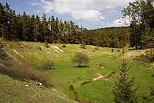
Dry valley

Dry valleys are valleys created by the erosion of water that only have flowing water temporarily or no longer at all .
The main reasons are changes in the climate , especially increasing drought ( aridity ), the drying out of river beds of intermittent or former (recent) waters and the underground discharge of water in humid areas. Several processes lead to the formation of these valleys: debris backfilling , the karst, and the formation of periglacial valleys.
In addition, the term is also used in a broader sense for valleys that were created by processes other than fluid, such as tectonics or volcanism , wind grinding , and did not develop a surface watercourse - up to exoplanetology , where the form processes are still unexplained (e.g. on Mars ).
Dry valleys in arid and semi-arid areas
In the semi-arid, low-precipitation areas, rivers are often only active in the rainy season or during heavy rain events ( intermittent watercourses ). Typical forms are the wadis in the desert areas of North Africa , the Middle East and partly in Spain as well as in Cyprus . In Europe, often in the Mediterranean, the Arroyos (Spanish), or the Torrentes (Italian: torrents and their gravel beds) and the Wieds on Malta .
In arid areas that previously received precipitation, existing valleys are drying up. In the case of episodic rains, which are usually very heavy, they are reactivated for a short time. In North Africa and the Middle East , wadis sometimes transport rainwater over very long distances, so that desert visitors who are not aware of the danger often drown in wadis.
Karst dry valleys
The underground drainage is a characteristic of the karst , so that dry valleys belong to the treasure trove of the karst. Through (mostly large-scale) tectonic movements, a water-soluble rock (e.g. limestone , gypsum , salt ) is lifted and reaches the area of the groundwater or directly to the surface of the earth. The drainage is first above ground. Due to the solubility of the rock and the penetration of water in existing crevices or carts , the subsoil dissolves and thus caves are formed . If the receiving water deepens , the groundwater level is also lowered. In this area, there is then an increased formation of caves and an increasing shift of drainage into the subsoil.
Initially, the amount of water in the flowing water decreases (examples of rivers with infiltration stretches : Danube infiltration , Lone infiltration , upper reaches of the Doubs / Loue source , French Jura ). The seepage areas or cracks in the limestone become larger and take on the shape of ponors or gullet holes . If the karst system (underground watercourse or cave systems) is large enough to completely absorb the flowing water for most of the year, the water bed is only reactivated if there is a large amount of water, for example due to floods caused by heavy rain or snowmelt ( turloughs in the Burren or "famine wells") on the Alb). Finally, the flowing water shifts completely underground, the former valley is dry all year round. A special feature are valleys that remain dry because a flowing water with great relief energy broke through in a different direction and created a new drainage valley and thus allowed the old bed to dry out (cf. river tap ).
In Germany there are dry valleys, for example, in the Swabian Alb , the Franconian Alb , the southeastern Black Forest , in the Paffrath Kalkmulde or the shell limestone plateaus in the northwest and southeast of Thuringia:

constantly dry:
- Wellheim dry valley
- Wental ( Albuch , Ostalb)
- Hasental, a glacial valley of the Miocene , above the Filsursprings (Middle Swabian Alb)
- Aitrachtal (lower part of Ur-Wutach / "Feldbergdonau" in the Black Forest)
- Schlade (Bergisch Gladbach)
intermittently:
- Lonetal and Hungerbrunnental on the Eastern Alb
- Helbetal and Schaftal in the north-west of Thuringia.
Periglacial dry valleys
The formation of the periglacial dry valleys, which are very widespread in Central Europe, took place under Ice Age climatic conditions with permafrost soil .
The melting and precipitation water created by the temporary thawing of layers close to the surface (“active layer”, see cryoturbation ) was forced to run off the surface by the sealing effect of the frozen subsoil. Pronounced gelifluction ("soil flow") on the water-soaked land surface and the sediment transport by meltwater runoff formed hollows and valleys in the landscape.
In the subsequent warm periods, the dissolution of the permafrost soil began to infiltrate the river water into the permeable or fissured subsoil, so that periglacial valleys could dry out. One example is the hype in Fläming .

