Loue
| Loue | ||
|
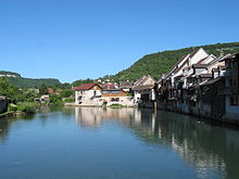
The Loue in Quingey |
||
| Data | ||
| Water code | FR : U26-0400 | |
| location | France , Bourgogne-Franche-Comte region | |
| River system | Rhône | |
| Drain over | Doubs → Saône → Rhône → Mediterranean | |
| source | in the municipality of Ouhans, 47 ° 0 ′ 41 ″ N , 6 ° 17 ′ 55 ″ E |
|
| Source height | approx. 535 m | |
| muzzle | on the municipal boundary of Parcey and Rahon in the Doubs Coordinates: 47 ° 0 ′ 48 ″ N , 5 ° 26 ′ 55 ″ E 47 ° 0 ′ 48 ″ N , 5 ° 26 ′ 55 ″ E |
|
| Mouth height | approx. 193 m | |
| Height difference | approx. 342 m | |
| Bottom slope | approx. 2.8 ‰ | |
| length | 122 km | |
| Left tributaries | Lison , Furieuse , Cuisance | |
| Right tributaries | Source du Pontet , Brême | |
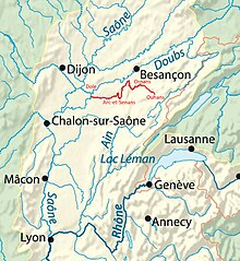
The Loue is a river in eastern France in the Bourgogne-Franche-Comté region . It rises from a rich karst spring in the municipality of Ouhans at an altitude of 535 m , drains in wide sweeping loops through the Folded Jura generally in a westerly direction and flows into the Doubs at Parcey .
geography
Source de la Loue
The Source de la Loue (Eng. Source of the Loue ) is the strongest karst spring in the Jura . It is located north of Ouhans and pours an average of 6,890 l / s. The masses of water flowing out of the spring have cut a powerful, vertical blade into the surrounding limestone layers. The spring water, which springs from a huge cave in the rock, comes from the upper Doubs , among other things , which partially seeps away at Pontarlier . This phenomenon was discovered when 1901 Absinth - distillery fell into Pontarlier in fire and flowed larger amounts Absinth into the river. A few days later the water in the Loue smelled strongly of anise . Subsequent staining experiments confirmed this observation.
course
After its origin, the Loue runs through a narrow wooded gorge with vertical limestone rock walls. There the water flows to the Source du Pontet . At Châtillon-sur-Lison the karst river Lison flows into the Loue, which in the following north-western course approaches the Doubs at Chenecey-Buillon for up to 2.5 km and bends to the southwest. The Loue flows after 122 kilometers at the municipal boundary of Parcey and Rahon from the left and east into the Doubs . On its way, the Loue crosses the Doubs and Jura departments .
From Ornans, the Loue is a popular migratory river for canoeists .
Tributaries


The main tributaries of the Loue are (downstream):
- Source du Pontet , from the right in front of Mouthier-Haute-Pierre
- Brême , from the right to Ornans
- Lison , from the left in front of Châtillon-sur-Lison
- Furieuse , from the left at Rennes-sur-Loue
- Larine , from left at Chamblay
- Cuisance , from the left at Souvans
A right oxbow lake at Parcey flows, a little above the river itself, together with the Clauge .
Places on the river
- Mouthier-Haute-Pierre
- Vuilla fans
- Montgesoye
- Ornans
- Chenecey Buillon
- Quingey
- Port Lesney
- Arc-et-Senans
- Cramans
- Chissey-sur-Loue
- Chamblay
- Parcey


