Montgesoye
| Montgesoye | ||
|---|---|---|

|
|
|
| region | Bourgogne-Franche-Comté | |
| Department | Doubs | |
| Arrondissement | Besançon | |
| Canton | Ornans | |
| Community association | Loue-Lison | |
| Coordinates | 47 ° 5 ' N , 6 ° 11' E | |
| height | 331-624 m | |
| surface | 11.06 km 2 | |
| Residents | 465 (January 1, 2017) | |
| Population density | 42 inhabitants / km 2 | |
| Post Code | 25111 | |
| INSEE code | 25400 | |
 Mairie Nontgesoye |
||
Montgesoye is a French municipality with 465 inhabitants (as of January 1 2017) in Doubs in the region Bourgogne Franche-Comté .
geography
Montgesoye is located at 356 m above sea level, four kilometers southeast of Ornans and about 21 kilometers south-southeast of the city of Besançon (as the crow flies). The village extends in the Jura , in the Loue valley at the confluence of the Ruisseau de Vaux, framed by the protrusions of the surrounding plateaus.
The area of the 11.06 km² large municipality covers a section of the western French Jura. The central part of the area is occupied by the Loue valley. The river flows here in a gently winding course through a flat valley floodplain about one kilometer wide from southeast to northwest. The erosion valley is cut around 250 m deep into the surrounding high plateaus. In the area of Montgesoye the Loue has several short side valleys, which are also cut deep into the high plateau, in the north the valley of the Ruisseau de Cornebouche , in the east that of the Ruisseau de Vaux . In between there are striking protrusions of the plateau. The steep slopes of the Loue and its side valleys are crowned at the upper edge in various places by striking rock walls of a resistant layer of limestone. In the west, the municipal area extends to the height of the Bois de la Soue and to the edge of the Amancey plateau. The highest point in Montgesoye is reached here at 624 m. To the east of the village are the heights of the Bois sur Roche (up to 600 m).
Neighboring municipalities of Montgesoye are Saules and Durnes in the north, Vuillafans in the east, Châteauvieux-les-Fossés and Chantrans in the south and Ornans in the west.
history
The beginnings of Montgesoye go back to the 9th century. A powerful aristocratic family lived here. The lords of Montgesoye are also considered to be the founders of the Mouthier-Haute-Pierre monastery . With the construction of the new, strategically better located castle Châteauvieux, the center of rule in the High Middle Ages shifted to the neighboring Châteauvieux. The old castle of Montgesoye was destroyed in 1636, but was later rebuilt. Together with Franche-Comté , Montgesoye came to France with the Peace of Nijmegen in 1678. Today Montgesoye is a member of the Loue-Lison community of 24 towns .
Attractions
The single-nave village church of Saint-Gengoux in Montgesoye dates from the 15th century, but was largely rebuilt in 1763 with the addition of the Gothic choir. Only the foundations of a tower from the 9th century and a Renaissance portal remain from the medieval castle of Montgesoye. Today there is a building from 1890 on the site. Also worth seeing is the Musée du Costume Comtois, in which traditional costumes and lace from the region are shown.

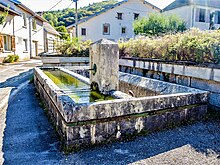
former lavoir
|
population
| Population development | |
|---|---|
| year | Residents |
| 1962 | 360 |
| 1968 | 396 |
| 1975 | 445 |
| 1982 | 437 |
| 1990 | 408 |
| 1999 | 432 |
| 2006 | 495 |
| 2016 | 472 |
With 465 inhabitants (January 1, 2017), Montgesoye is one of the small communities in the Doubs department. After the population had decreased markedly in the first half of the 20th century (600 people were still counted in 1881), a significant increase in population has been recorded again in recent years.
Economy and Infrastructure
Until well into the 20th century, Montgesoye was a village dominated by agriculture (arable farming, fruit growing and cattle breeding). The water power of the Loue was used early on to operate mills. Today there are some small businesses, including in the wood processing and staircase construction industries, as well as various craft businesses. In the meantime, the village has also turned into a residential community. Many workers are commuters who work in the larger towns in the area.
The village is well developed in terms of traffic. It is located on the D67 departmental road from Ornans to Pontarlier . Another road connection exists with Durnes.
Montgesoye station on the L'Hôpital-du-Grosbois-Lods railway line has been closed along with the line.
literature
- Le Patrimoine des Communes du Doubs. Volume 2, Flohic Editions, Paris 2001, ISBN 2-84234-087-6 , pp. 848-849.


