
Mérey-sous-Montrond
| Mérey-sous-Montrond | ||
|---|---|---|

|
|
|
| region | Bourgogne-Franche-Comté | |
| Department | Doubs | |
| Arrondissement | Besançon | |
| Canton | Ornans | |
| Community association | Loue-Lison | |
| Coordinates | 47 ° 9 ' N , 6 ° 4' E | |
| height | 380-522 m | |
| surface | 10.79 km 2 | |
| Residents | 430 (January 1, 2017) | |
| Population density | 40 inhabitants / km 2 | |
| Post Code | 25660 | |
| INSEE code | 25375 | |
 Mairie Mérey-sous-Montrond |
||

Mérey-sous-Montrond is a French municipality with 430 inhabitants (as of January 1 2017) in Doubs in the region Bourgogne Franche-Comté .
geography
Mérey-sous-Montrond is at 460 m above sea level, about ten kilometers south of the city of Besançon (as the crow flies). The village extends in the Jura , on the first plateau between the Jura ridge in the north and the height of Malbrans in the south, at the northern foot of the hill of Mérey.
The area of the 10.79 km² municipality covers a section of the stratified landscape of the western French Jura. The main part of the area is occupied by the Mérey plateau, which is an average of 450 m. It consists partly of arable land and meadow, partly of forest (especially the Grand Bois in the north). The entire plateau has no surface watercourses because the rainwater seeps into the karstified subsoil. The landscape is characterized by various karst phenomena such as sinkholes , covered cart fields , caves and shafts. To the south of the village, the communal soil extends up to the Mont , on which the highest point of Mérey-sous-Montrond is reached at 522 m. It represents a spur of the next higher layer level reaching far to the north . To the north, the community area extends over an approximately 50 m high step down into the Granges basin.
The hamlet of Granges-du-Liège ( 405 m ) in a valley north of the Grand Bois belongs to Mérey-sous-Montrond . Neighboring municipalities of Mérey-sous-Montrond are Fontain and La Vèze in the north, Tarcenay-Foucherans with Tarcenay and Villers-sous-Montrond in the east and Montrond-le-Château in the west.
history
In the Middle Ages, Mérey belonged to the lordship of Montrond. Together with Franche-Comté , the village came to France with the Peace of Nijmegen in 1678. The area changed in 1822 when the previously independent Granges-du-Liège was incorporated into Mérey-sous-Montrond. Today Mérey-sous-Montrond is a member of the Loue-Lison municipal association .
Attractions
The village church of Saint-Sébastien in Mérey-sous-Montrond was rebuilt between 1839 and 1841. In the center there are numerous farmhouses in the characteristic style of Franche-Comté from the 17th to 19th centuries. The Château de Grange Céry is located in the groves of the Grand Bois. The Mérey karst nature trail is also worth a visit.
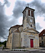
Saint-Sébastien church

Château de Grange Céry

.jpg)
population
| Population development | |
|---|---|
| year | Residents |
| 1962 | 152 |
| 1968 | 178 |
| 1975 | 187 |
| 1982 | 402 |
| 1990 | 422 |
| 1999 | 421 |
| 2006 | 433 |
| 2016 | 424 |
With 430 inhabitants (January 1, 2017), Mérey-sous-Montrond is one of the small communities in the Doubs department. After the population in the 20th century until the mid-1970s had always been in the range of around 180 people, a striking population growth has been recorded since then.
Economy and Infrastructure
Mérey-sous-Montrond was a village characterized by agriculture (arable farming, fruit growing and cattle breeding) and forestry until well into the 20th century. Today there are some small businesses, including in the wood processing and construction industries. In the meantime, the village has also turned into a residential community. Many workers are commuters who work in the larger towns in the area.
The village is located off the major thoroughfares on a departmental road that leads from Épeugney to Tarcenay. There are other road connections with Villers-sous-Montrond and La Vèze.
literature
- Le Patrimoine des Communes du Doubs. Volume 2, Flohic Editions, Paris 2001, ISBN 2-84234-087-6 , p. 847.