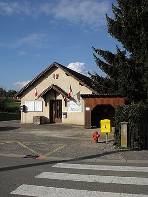
L'Écouvotte
| L'Écouvotte | ||
|---|---|---|
|
|
||
| region | Bourgogne-Franche-Comté | |
| Department | Doubs | |
| Arrondissement | Besançon | |
| Canton | Baume-les-Dames | |
| Community association | Doubs Baumois | |
| Coordinates | 47 ° 20 ′ N , 6 ° 15 ′ E | |
| height | 325-383 m | |
| surface | 2.16 km 2 | |
| Residents | 92 (January 1, 2017) | |
| Population density | 43 inhabitants / km 2 | |
| Post Code | 25640 | |
| INSEE code | 25215 | |
 Mairie L'Écouvotte |
||
L'Écouvotte is a French commune with a population of 92 (as at 1st January 2017) in the Doubs department in the region of Bourgogne Franche-Comté .
geography
L'Écouvotte is located at 335 m , eight kilometers west of Baume-les-Dames and about 21 kilometers northeast of the city of Besançon (as the crow flies). The village extends in the undulating landscape between the river valleys of Doubs and Ognon , on the south-eastern edge of a wide basin at the foot of the Pinfou forest.
The area of the 2.16 km² large municipal area includes a section in the extreme northwestern mountain ranges of the Jura . The central part of the area is occupied by a basin, which is on average 320 m and opens to the west to a wide basin. It is predominantly made up of arable and meadow land. This hollow is flanked in the north by the Bois du Chanoi hill . To the south, the municipality extends to the ridge of the Bois du Pinfou , on which the highest point of L'Écouvotte is reached at 383 m. There are no above-ground rivers in the entire area because the rainwater seeps into the karstified subsoil.
Neighboring municipalities of L'Écouvotte are Le Puy and Val-de-Roulans in the north, Breconchaux in the east and Saint-Hilaire in the south.
population
| Population development | |
|---|---|
| year | Residents |
| 1962 | 33 |
| 1968 | 25th |
| 1975 | 24 |
| 1982 | 50 |
| 1990 | 53 |
| 1999 | 73 |
| 2016 | 93 |
With 92 inhabitants (as of January 1, 2017), L'Écouvotte is one of the smallest communities in the Doubs department. After the population had decreased significantly in the first half of the 20th century (72 people were still counted in 1901), population growth has been recorded again since the mid-1970s. Since then, the population has quadrupled.
Economy and Infrastructure
Until well into the 20th century, L'Écouvotte was a village dominated by agriculture (arable farming, fruit growing and cattle breeding) and forestry. Even today, the residents live mainly from their work in the first sector. Outside the primary sector there are few jobs in the village. Some workers are also commuters who work in the surrounding larger towns.
The village is located away from the major thoroughfares on a departmental road that leads from Pouligney to Séchin. The nearest connection to the A36 motorway , which crosses the municipality, is approximately eleven kilometers away. Another road connection is with Le Puy.
literature
- Le Patrimoine des Communes du Doubs. Volume 2, Flohic Editions, Paris 2001, ISBN 2-84234-087-6 , p. 1148.
