Paroy (Doubs)
| Paroy | ||
|---|---|---|
|
|
||
| region | Bourgogne-Franche-Comté | |
| Department | Doubs | |
| Arrondissement | Besançon | |
| Canton | Saint Vit | |
| Community association | Loue-Lison | |
| Coordinates | 47 ° 3 ' N , 5 ° 53' E | |
| height | 276-572 m | |
| surface | 4.37 km 2 | |
| Residents | 126 (January 1, 2017) | |
| Population density | 29 inhabitants / km 2 | |
| Post Code | 25440 | |
| INSEE code | 25445 | |
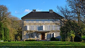
 Paroy Castle |
||
Paroy is a French municipality with 126 inhabitants (as of January 1 2017) in Doubs in the region Bourgogne Franche-Comté .
geography
Paroy is located at 325 m , south of Quingey , about 25 kilometers south-southwest of the city of Besançon (as the crow flies). The village extends in the western Jura , on a plateau-like hill east of the Loue at the foot of the Bois de la Chau .
The area of the 4.37 km² large municipality covers a section of the western French Jura. The northern part of the area is taken up by the Paroy plateau, which lies in a wide basin between the extreme ridges of the Jura at about 320 m . It gradually descends towards the northwest towards the Loue. The community area extends to the south-east over a wooded slope up to the ridges of Bois de la Chau and By. This ridge belongs to a Jura chain that stretches north from Mont Poupet to the bend of the Loue river. Here, at 572 m, Paroy's highest point is reached.
Paroy's neighboring communities are Samson in the north, Ronchaux in the east, By in the south and Chay and Brères in the west.
history
Paroy was first mentioned in a document in the 13th century. In the Middle Ages the village belonged to the Rennes-sur-Loue domain. Together with Franche-Comté , it came to France with the Peace of Nijmegen in 1678.
Attractions
The Saint-Étienne church was built in the early 15th century in Gothic styles. Paroy has a manor house and various farmhouses in the characteristic style of Franche-Comté from the 17th to 19th centuries.
population
| Population development | |
|---|---|
| year | Residents |
| 1962 | 98 |
| 1968 | 80 |
| 1975 | 83 |
| 1982 | 93 |
| 1990 | 85 |
| 1999 | 96 |
| 2005 | 109 |
| 2016 | 124 |
With 126 inhabitants (as of January 1, 2017) Paroy is one of the smallest communities in the Doubs department. After the population had decreased in the first half of the 20th century (179 people were still counted in 1886), only minor fluctuations have been recorded since the early 1960s.
Economy and Infrastructure
Until well into the 20th century, Paroy was mainly a village characterized by agriculture (arable farming, fruit growing and cattle breeding) and forestry. In addition, there are now some local small businesses. In the meantime, the village has also turned into a residential community. Many workers are commuters who work in the larger towns in the area.
The village is well developed in terms of traffic. It is on the main road N83 , which leads from Besançon to Lons-le-Saunier . Other road connections exist with Chay, Ronchaux and By.
literature
- Le Patrimoine des Communes du Doubs. Volume 2, Flohic Editions, Paris 2001, ISBN 2-84234-087-6 , pp. 1067-1069.
