Ougney-Douvot
| Ougney-Douvot | ||
|---|---|---|
|
|
||
| region | Bourgogne-Franche-Comté | |
| Department | Doubs | |
| Arrondissement | Besançon | |
| Canton | Baume-les-Dames | |
| Community association | Doubs Baumois | |
| Coordinates | 47 ° 19 ′ N , 6 ° 15 ′ E | |
| height | 255-589 m | |
| surface | 6.56 km 2 | |
| Residents | 253 (January 1, 2017) | |
| Population density | 39 inhabitants / km 2 | |
| Post Code | 25640 | |
| INSEE code | 25439 | |
| Website | www.ougney-douvot.com | |
 Mairie Ougney-Douvot |
||
Ougney-Douvot is a French municipality with 253 inhabitants (as of January 1 2017) in Doubs in the region Bourgogne Franche-Comté .
geography
Ougney-Douvot is located at 279 m , seven kilometers west-southwest of Baume-les-Dames and about 21 kilometers east-northeast of the city of Besançon (as the crow flies). The village extends in the Doubstal , in the extreme northwestern mountain ranges of the Jura , between the plateau of Séchin in the north and the Côte (Jura border chain) in the south.
The area of the 6.56 km² municipal area includes a section of the Doubstal. The Doubs flows here with several turns through a mostly 500 to 700 m wide flat floodplain to the west-south-west and at the same time forms the waterway of the Rhine-Rhône Canal . The valley is deeply cut between two mountain ranges of the system of the Jura ridge. To the north of the Doube valley, a steep slope, partly criss-crossed by ledges, leads over to the Séchin plateau (up to 340 m). Much higher rises south of the Doubs the long ridge of the Bois de la Côte , which forms an anticline from a geological and tectonic point of view and is oriented towards the west-south-west-east-north-east in accordance with the direction of the Jura in this region. At 589 m, the highest point of Ougney-Douvot is reached at the height of the Côte.
The municipality of Ougney-Douvot consists of several districts:
- Ougney-les-Champs ( 279 m ) on the north bank of the Doubs
- Ougney-le-Bas ( 265 m ) on the south bank of the Doubs
- Ougney-la-Roche ( 265 m ) on the south bank of the Doubs
- Douvot ( 262 m ) on the north bank of the Doubs
Neighboring municipalities of Ougney-Douvot are Breconchaux , Séchin and Fourbanne in the north, Esnans in the east, Bretigney-Notre-Dame , Dammartin-les-Templiers and Champlive in the south and Laissey and Roulans in the west.
history
In the 12th century a priory was founded in Ougney-le-Bas, whose monks cleared the area and made it arable. The priory lasted until the 15th century. The priory included a manor house that was rebuilt in the 15th century. Together with Franche-Comté , Ougney finally came to France with the Peace of Nijmegen in 1678. The three districts of Ougney were grouped together under the name of Les Trois Oigneÿ before the French Revolution . Douvot merged with Les Trois-Ougney in 1818 to form the new municipality of Ougney-Douvot. The metalworking industry developed in Douvot in the course of the 19th century, with some of the iron ore extracted not far from Ougney-Douvot being processed. In 1870 the steel factory was founded, which at times employed more than 100 workers, specialized in the manufacture of tools (pliers) and iron goods in the 20th century and ceased operations in 1968.
Attractions
Chapels are in Ougney-les-Champs and Douvot. The manor house in Ougney-le-Bas dates from the 15th century. Source Bleue is located between Ougney-les-Champs and Douvot .
population
| Population development | |
|---|---|
| year | Residents |
| 1962 | 235 |
| 1968 | 260 |
| 1975 | 212 |
| 1982 | 168 |
| 1990 | 159 |
| 1999 | 150 |
| 2005 | 169 |
| 2016 | 249 |
With 253 inhabitants (as of January 1, 2017), Ougney-Douvot is one of the small communities in the Doubs department. After the population in the first half of the 20th century was mostly in the range between 280 and 350 people, a population decline has been recorded since the beginning of the 1950s. The population has remained at almost the same level since around 1980.
Economy and Infrastructure
Since the late 18th century, Ougney-Douvot has been a village characterized by its water-dependent industry. Today there are various local small businesses. In the meantime, the village has also turned into a residential community. Many workers are therefore commuters who work in the larger towns in the area.
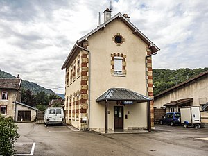
The village is located away from the major thoroughfares on a departmental road that leads from Laissey to Séchin. The closest connection to the A36 motorway is around twelve kilometers away. Another road connection is with Esnans. Ougney and Douvot each have a station on the Besançon – Montbéliard section of the Dole – Belfort railway line, which opened in 1858 , but both stations are no longer served.
literature
- Le Patrimoine des Communes du Doubs. Volume 2, Flohic Editions, Paris 2001, ISBN 2-84234-087-6 , pp. 1160-1162.
Web links
Individual evidence
- ^ De l'ère industrial à nos jours. Website of the municipality of Ougney-Douvot
