Battenans-les-Mines
| Battenans-les-Mines | ||
|---|---|---|
|
|
||
| region | Bourgogne-Franche-Comté | |
| Department | Doubs | |
| Arrondissement | Besançon | |
| Canton | Baume-les-Dames | |
| Community association | Doubs Baumois | |
| Coordinates | 47 ° 25 ' N , 6 ° 16' E | |
| height | 256-404 m | |
| surface | 2.78 km 2 | |
| Residents | 54 (January 1, 2017) | |
| Population density | 19 inhabitants / km 2 | |
| Post Code | 25640 | |
| INSEE code | 25045 | |
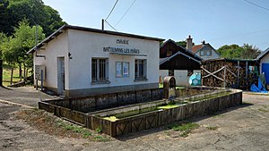
 Mairie and former washing area with cattle trough |
||
Battenans-les-Mines is a French commune with a population of 54 (as at 1st January 2017) in the Doubs department in the region of Bourgogne Franche-Comté .
geography
Battenans-les-Mines is 300 m , ten kilometers northwest of Baume-les-Dames and about 26 kilometers northeast of the city of Besançon (as the crow flies). The village extends in a panoramic position on a slope of the Bois des Perrières inclined to the north-west, south of the valley of the Ognon , in the undulating landscape in the extreme north-west of the Doubs department.
The area of the 2.78 km² municipal area comprises a section of the hilly landscape between the river valleys of Doubs and Ognon. The central part of the area is occupied by a relatively gently sloping slope that rises south to the wooded height of the Bois des Perrières . The highest point of Battenans-les-Mines is reached here at 404 m. This height is flanked in the west by the valley of the Ruisseau de la Beune , in the east by a valley basin without above-ground running water, which opens to the valley of the Crenu . However, the municipal area does not reach down to the valley floor.
Neighboring municipalities of Battenans-les-Mines are Avilley in the north, Tallans in the east, Tournans and La Bretenière in the south and Rougemontot and Cendrey in the west.
history
Iron ore was mined at Battenans early on. In order to avoid confusion with other communes of the same name, Battenans was officially renamed Battenans-les-Mines in 1936. Today the village is part of the Doubs Baumois municipal association .
population
| Population development | |
|---|---|
| year | Residents |
| 1962 | 57 |
| 1968 | 50 |
| 1975 | 41 |
| 1982 | 50 |
| 1990 | 48 |
| 1999 | 57 |
| 2016 | 57 |
With 54 inhabitants (as of January 1, 2017), Battenans-les-Mines is one of the smallest municipalities in the Doubs department. After the population had decreased significantly in the first half of the 20th century (100 people were still counted in 1886), only minor fluctuations have been recorded since the early 1960s.
Economy and Infrastructure
Until well into the 20th century, Battenans-les-Mines was a village dominated by agriculture (arable farming, fruit growing and cattle breeding). Even today, the residents live mainly from their work in the first sector. Outside the primary sector there are few jobs in the village. Some workers are also commuters who work in the surrounding larger towns.
The village is located off the major thoroughfares on a departmental road that leads from Avilley to La Bretenière. The closest connection to the A36 motorway is around 17 kilometers away. Another road connection is with Cendrey.
