Villers-Saint-Martin
| Villers-Saint-Martin | ||
|---|---|---|
|
|
||
| region | Bourgogne-Franche-Comté | |
| Department | Doubs | |
| Arrondissement | Besançon | |
| Canton | Baume-les-Dames | |
| Community association | Doubs Baumois | |
| Coordinates | 47 ° 21 ' N , 6 ° 25' E | |
| height | 317-520 m | |
| surface | 8.90 km 2 | |
| Residents | 212 (January 1, 2017) | |
| Population density | 24 inhabitants / km 2 | |
| Post Code | 25110 | |
| INSEE code | 25626 | |
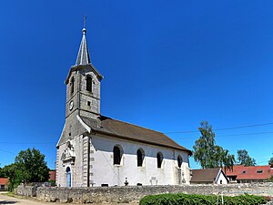
 Saint Martin Church |
||
Villers-Saint-Martin is a French municipality with 212 inhabitants (as of January 1 2017) in Doubs in the region Bourgogne Franche-Comté .
geography
Villers-Saint-Martin is 350 m , four kilometers east-southeast of Baume-les-Dames and about 31 kilometers east-northeast of the city of Besançon (as the crow flies). The village extends in the Jura , in a depression between the Jura rim range in the north and the western foothills of the Lomont range in the south.
The area of the 8.90 km² municipal area covers a section of the French Jura. The central part of the area is occupied by the Villers depression, which is a maximum of 1.5 kilometers wide, about six kilometers long and an average of 350 m. It is oriented according to the strike direction of the Jura in this region towards west-southwest-east-northeast. The area is predominantly made up of arable land and meadows and has no surface watercourses because the rainwater seeps into the karstified subsoil.
To the north, the area extends to the narrow crest of the Bois de Babre ( 512 m ), which belongs to the Jura ridge. It separates the Villers Depression from the Doubstal, which runs to the north . The ridge is bounded in the west by the breakthrough of the Cusancin and in the east by the cross valley of the Doubs. In the south the community area extends to the ridge of the Bois du Saussoi , which forms the westernmost foothills of the Lomont chain. Here, at 520 m, the highest point in Villers-Saint-Martin is reached.
In addition to the actual village, Villers-Saint-Martin also includes various hamlets and individual farms, including:
- Sur la Layenne ( 360 m ) in the western section of the Villers valley
- Sur Plénise ( 352 m ) in the valley of Villers
- Plénise ( 345 m ) in the valley of Villers
Neighboring municipalities of Villers-Saint-Martin are Baume-les-Dames and Hyèvre-Magny in the north, Lomont-sur-Crête in the east, Guillon-les-Bains in the south and Pont-les-Moulins in the west.
history
In the Middle Ages Villers was part of the Baume castellanei . Together with Franche-Comté , the village came to France with the Peace of Nijmegen in 1678. The community was called Villers-le-Sec until 1922, when it was officially given its current name.
Attractions
The village church of Saint-Martin in Villers-Saint-Martin was built in the 18th century in the classical style.
population
| Population development | |
|---|---|
| year | Residents |
| 1962 | 131 |
| 1968 | 116 |
| 1975 | 119 |
| 1982 | 161 |
| 1990 | 198 |
| 1999 | 190 |
| 2005 | 200 |
| 2005 | 216 |
With 212 inhabitants (as of January 1, 2017) Villers-Saint-Martin is one of the small communities in the Doubs department. After the population had decreased in the first half of the 20th century (1901 were still 204 people), population growth has been recorded again since the mid-1970s.
Economy and Infrastructure
Until well into the 20th century, Villers-Saint-Martin was primarily a village characterized by agriculture (arable farming, fruit growing and cattle breeding) and forestry. In addition, there are now some local small businesses. Many workers are also commuters who work in the larger towns in the area.
The village is located off the major thoroughfares on a departmental road that leads from Pont-les-Moulins to Hyèvre-Magny. Other road connections exist with Baume-les-Dames and Lomont-sur-Crête.
