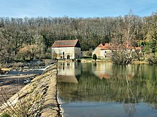
Montagney-Servigney
| Montagney-Servigney | ||
|---|---|---|
|
|
||
| region | Bourgogne-Franche-Comté | |
| Department | Doubs | |
| Arrondissement | Besançon | |
| Canton | Baume-les-Dames | |
| Community association | Deux Vallées Vertes | |
| Coordinates | 47 ° 29 ′ N , 6 ° 18 ′ E | |
| height | 241-297 m | |
| surface | 6.55 km 2 | |
| Residents | 132 (January 1, 2017) | |
| Population density | 20 inhabitants / km 2 | |
| Post Code | 25680 | |
| INSEE code | 25385 | |
Montagny-Servigney is a French municipality with 132 inhabitants (as of January 1 2017) in Doubs in the region Bourgogne Franche-Comté .
geography
Montagney-Servigney is located at an altitude of 258 m above sea level, four kilometers west of Rougemont and about 35 kilometers west of the city of Montbéliard (as the crow flies). The village extends on the edge of the valley of the Ognon in the gently undulating landscape.
The area of the 6.55 km² municipal area includes a section of the central Ognontal. The western and northern borders mostly run along the Ognon, which flows here with several turns through a valley about one kilometer wide. In the area of the historic ironworks with a blast furnace from the 18th century, a small portion to the right of the river also belongs to the community. From the course of the river, the community area stretches southeast over the alluvial plain to the high terrace and the plateau, which rises slightly towards the adjacent hilly landscape. It is subdivided by the cuts of two short side streams of the Ognon. The area shows a loose structure of arable and meadow land, which is interrupted by larger forest areas (Bois Dessous, Bois Dessus). At 297 m, the highest point of Montagney-Servigney is reached on the plateau.
The double community consists of the following districts:
- Montagney ( 258 m ) in an arc of the Ognon extending to the northwest at the edge of the valley floor
- La Forge ( 260 m , only one building complex) on the right (north) side of the Ognon opposite Montagney
- Servigney ( 270 m ) in a hollow on the eastern edge of the Ognon valley
The neighboring communities of Montagney-Servigney are Cognières and Thieffrans in the north, Rougemont in the east, Mondon and Montussaint in the south, and Montbozon , Thiénans and Bouhans-lès-Montbozon in the west.
history
The municipality of Montagney-Servigney was populated very early. A burial ground from the La Tène period with rich grave goods was discovered near Servigney . In the Middle Ages, the villages of Montagney and Servigney were under the influence of the Rougemont rule. Together with Franche-Comté , both villages came to France with the Peace of Nijmegen in 1678.
The first blast furnace was put into operation near Montagney around 1500. In the course of time an important forge and cast iron works developed, which in 1748 mainly produced cannon balls (annual production approx. 30,000 pieces). In 1833 a wire drawing shop was added. From the mid-1850s, however, the plant began to rapidly decline, because, on the one hand, the forests had been cut down to produce charcoal and, on the other hand, the iron ore deposits, some of which were close to the surface, were exhausted. Since 2009 the still existing blast furnace has been restored on a private initiative through an association. An educational trail on the subject of "iron production" will also be created. An old-style charcoal burner's hut, a limestone quarry and tools from cast iron production can be viewed in a temporary exhibition. The previously independent localities Montagney and Servigney merged in 1973 to form today's dual community. Today Montagney-Servigney is a member of the Deux Vallées Vertes community of municipalities .
Attractions
The La Forge settlement is classified as a Monument Historique and is an important cultural monument of the industrial age with a blast furnace from the 18th century. The residence of the former Maître de Forge from the 18th century and workers' houses still exist. Servigney has the church, built in 1750, and a lavoir that was restored in 2005. More recently, an extensively signposted educational trail has been built in the immediate vicinity of the blast furnace, which deals with iron extraction at the original sites (mining of ore and limestone, extraction of charcoal) in the village.
population
| Population development | |
|---|---|
| year | Residents |
| 1962 | 119 |
| 1968 | 115 |
| 1975 | 111 |
| 1982 | 111 |
| 1990 | 130 |
| 1999 | 112 |
| 2007 | 108 |
| 2016 | 129 |
With 132 inhabitants (as of January 1, 2017) Montagney-Servigney is one of the smallest communities in the Doubs department. After the number of inhabitants had decreased significantly in the first half of the 20th century (235 people were counted in 1881), only minor fluctuations have been recorded since then.
Economy and Infrastructure
Once shaped by the ironworks, Montagney-Servigney is now mainly oriented towards agriculture (arable farming, fruit growing and cattle breeding) and forestry. There are also some local small businesses. In the meantime the village has turned into a residential community. Many workers are therefore commuters who work in the larger towns in the area.
The village is off the major thoroughfares on a departmental road that leads from Thieffrans to Mondon. Further road connections exist with Montbozon and Rougemont.
literature
- Le Patrimoine des Communes du Doubs. Volume 2, Flohic Editions, Paris 2001, ISBN 2-84234-087-6 , pp. 1114-1116.

