
Marchaux-Chaudefontaine
| Marchaux-Chaudefontaine | ||
|---|---|---|
|
||
| region | Bourgogne-Franche-Comté | |
| Department | Doubs | |
| Arrondissement | Besançon | |
| Canton | Besançon-4 | |
| Community association | Grand Besançon | |
| Coordinates | 47 ° 19 ′ N , 6 ° 8 ′ E | |
| height | 279-530 m | |
| surface | 16.39 km 2 | |
| Residents | 1,464 (January 1, 2017) | |
| Population density | 89 inhabitants / km 2 | |
| Post Code | 25640 | |
| INSEE code | 25368 | |
 Mairie - Lavoir in Marchaux |
||

Marchaux-Chaudefontaine is a French commune with 1,464 inhabitants (as of January 1 2017) in Doubs in the region Bourgogne Franche-Comté . It belongs to the canton of Besançon-4 in the arrondissement of Besançon .
The municipality was created on January 1, 2018 through the merger of the two municipalities of Marchaux and Chaudefontaine .
geography
Marchaux-Chaudefontaine is about twelve kilometers northeast of Besançon . Marchaux-Chaudefontaine is surrounded by the neighboring communities of Venise , Champoux and Moncey in the north, Corcelle-Mieslot in the northeast, Pouligney-Lusans and Châtillon-Guyotte in the east, Amagney in the south, Thise and Braillans in the southwest and Vieilley in the west.
The A36 autoroute runs through the municipality .
structure
| District | former INSEE code |
Area (km²) | Population (2015) |
|---|---|---|---|
| Chaudefontaine | 25137 | 6.33 | 212 |
| Marchaux (administrative headquarters) | 25368 | 10.06 | 1,235 |
Attractions
- Saint-Martin church in Marchaux, originally from the 10th century, rebuilt from 1715 to 1719
- Chapel of Saint-Guérin in Chaudefontaine
- Wash house in Marchaux from 1826, monument historique since 1990
- Saint-Guérin wash house
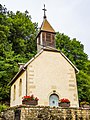
Saint-Guérin Chapel

Web links
Individual evidence
- ↑ Arrêté portant creation de la commune nouvelle de Marchaux-Chaudefontaine. December 4, 2017, accessed January 19, 2018 (French).
- ↑ Population figures retrospectively as of January 1, 2015