
Chaudefontaine (Doubs)
| Chaudefontaine | ||
|---|---|---|
|
||
| local community | Marchaux-Chaudefontaine | |
| region | Bourgogne-Franche-Comté | |
| Department | Doubs | |
| Arrondissement | Besançon | |
| Coordinates | 47 ° 20 ' N , 6 ° 10' E | |
| Post Code | 25640 | |
| Former INSEE code | 25137 | |
| Incorporation | 1st January 2018 | |

Chaudefontaine is a village and a former municipality with 212 last inhabitants (1 January 2015) in the French department of Doubs in the region Bourgogne Franche-Comté .
On January 1, 2018, Chaudefontaine was merged with the municipality of Marchaux to form the new municipality ( Commune nouvelle ) Marchaux-Chaudefontaine .
geography
Chaudefontaine is located at 280 m , about 15 kilometers northeast of the city of Besançon (as the crow flies). The village extends in the undulating landscape between the river valleys of Doubs and Ognon , in a depression between the hill of Châtillon-Guyotte in the south and the foothills of the Grande Côte in the north.
The area of the 6.33 km² large municipal area includes a section in the extreme northwestern mountain ranges of the Jura . The main part of the area is occupied by a wide basin, which is drained by the Ruisseau de la Corcelle to the northeast to the Ognon. It is subdivided by various short valleys. This valley consists partly of arable land and meadow, partly of forest. To the north, the municipality extends to the wooded ridge of the Bois du Fays , on which the highest point of Chaudefontaine is reached at 448 m.
Neighborhoods of Chaudefontaine are Moncey in the north, Corcelle-Mieslot and Pouligney-Lusans in the east, Châtillon-Guyotte and Marchaux in the south and Champoux in the west.
history
Chaudefontaine is named after several springs that arise near the village. In the Middle Ages, the village belonged to the Châtillon-Guyotte domain. Together with Franche-Comté , it finally came to France with the Peace of Nijmegen in 1678.
Attractions
The single-nave Saint-Guérin chapel was built in the 18th century.
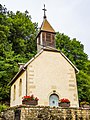
Saint-Guérin Chapel

former town hall


population
| Population development | |
|---|---|
| year | Residents |
| 1962 | 140 |
| 1968 | 141 |
| 1975 | 206 |
| 1982 | 245 |
| 1990 | 215 |
| 1999 | 208 |
| 2015 | 212 |
With its last 212 inhabitants (as of January 1, 2015), Chaudefontaine was one of the small communities in the Doubs department. After the population had steadily decreased in the first half of the 20th century (212 people were still counted in 1901), significant population growth was recorded, especially during the 1970s. Since then, a slight downward trend has been observed again.
Economy and Infrastructure
Until well into the 20th century, Chaudefontaine was a village dominated by agriculture (arable farming, fruit growing and cattle breeding) and forestry. Today there are also various local small business and retail businesses. A commercial zone has developed on the outskirts since the 1970s, which includes, among other things, metal construction and construction companies. In the meantime, the village has also turned into a residential community. Many workers are therefore commuters who go to work in the Besançon agglomeration.
The village is well developed in terms of traffic. It is located on the departmental road from Besançon to Rougemont . The nearest connection to the A36 motorway , which crosses the municipality, is around two kilometers away. There are other road connections with Moncey, Champoux and Châtillon-Guyotte.
Individual evidence
- ↑ Arrêté portant creation de la commune nouvelle de Marchaux-Chaudefontaine. December 4, 2017, accessed January 19, 2018 (French).