Moncey
| Moncey | ||
|---|---|---|

|
|
|
| region | Bourgogne-Franche-Comté | |
| Department | Doubs | |
| Arrondissement | Besançon | |
| Canton | Baume-les-Dames | |
| Community association | Doubs Baumois | |
| Coordinates | 47 ° 22 ′ N , 6 ° 7 ′ E | |
| height | 219-446 m | |
| surface | 5.00 km 2 | |
| Residents | 579 (January 1, 2017) | |
| Population density | 116 inhabitants / km 2 | |
| Post Code | 25870 | |
| INSEE code | 25382 | |
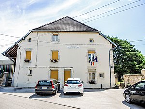
 Mairie Moncry |
||
Moncey is a French municipality with 579 inhabitants (as of January 1 2017) in Doubs in the region Bourgogne Franche-Comté .
geography
Moncey is located at 233 m, about 16 kilometers north-northeast of the city of Besançon (as the crow flies). The village extends in a slightly elevated position on the southern edge of the valley low of the Ognon , north of the ridge of the Grande Côte in the extreme north-west of the Doubs department.
The area of the 5.00 km² municipal area covers a section of the Ognon valley. The north-western border runs along the Ognon, which flows here with large river loops through a roughly one kilometer wide, flat valley depression. From the course of the river, the community area extends to the east over the formerly boggy floodplain into a gently undulating landscape, which is partly made up of arable land and meadows, partly with forest. The Bois Bas extends east of the village and the Bois de Moncey to the south . In the far south-east, the communal soil extends to the ridge of the Bois du Mont . This ridge represents the north-eastern continuation of the ridge of the Grande Côte and forms an anticline in geological and tectonic terms . With 446 m, the highest point of Moncey is reached here.
The neighboring communities of Moncey are Thurey-le-Mont in the north, Rigney and Marchaux-Chaudefontaine in the east, Venise in the south and Aulx-lès-Cromary in the west.
Attractions
The single-nave church Notre-Dame de la Nativité de la Sainte-Vierge was built in the 18th century. The Château du Maréchal Moncey also dates from the 18th century and was the residence of Bon-Adrien-Jeannot de Moncey .

Lavoir in Moncry
|
population
| Population development | |
|---|---|
| year | Residents |
| 1962 | 262 |
| 1968 | 233 |
| 1975 | 217 |
| 1982 | 349 |
| 1990 | 363 |
| 1999 | 379 |
| 2004 | 415 |
| 2016 | 563 |
With 579 inhabitants (as of January 1, 2017) Moncey is one of the small communities in the Doubs department. After the population in the first half of the 20th century had always been in the range between 200 and 300 people, there has been a significant increase in population since the mid-1970s. Since then the population has almost doubled.
Economy and Infrastructure
Until well into the 20th century, Moncey was a village dominated by agriculture (arable farming, fruit growing and cattle breeding) and forestry. Today there are also various local small business and retail businesses. In the meantime, the village has also turned into a residential community. Many workers are therefore commuters who go to work in the Besançon agglomeration.
The village is located off the major thoroughfares on a departmental road that leads from Chaudefontaine to Rioz . The closest connection to the A36 motorway is around nine kilometers away. Further road connections exist with Rigney, Devecey, Palise and Cirey.
Personalities
- Bon-Adrien-Jeannot de Moncey (1754–1842), French general and marshal


