Montrond-le-Château
| Montrond-le-Château | ||
|---|---|---|

|
|
|
| region | Bourgogne-Franche-Comté | |
| Department | Doubs | |
| Arrondissement | Besançon | |
| Canton | Saint Vit | |
| Community association | Loue-Lison | |
| Coordinates | 47 ° 9 ' N , 6 ° 3' E | |
| height | 407-525 m | |
| surface | 10.90 km 2 | |
| Residents | 561 (January 1, 2017) | |
| Population density | 51 inhabitants / km 2 | |
| Post Code | 25660 | |
| INSEE code | 25406 | |
| Website | www.montrond-le-chateau.fr | |
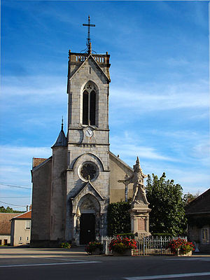
 Saint-Georges church |
||
Montrond-le-Chateau is a French commune with a population of 561 (as at 1st January 2017) in the Doubs department in the region of Bourgogne Franche-Comté .
geography
Montrond-le-Château is located at 456 m , about eleven kilometers south of the city of Besançon (as the crow flies). The village extends in the Jura , on the first plateau between the Jura ridge in the north and the height of Malbrans in the south, at the western foot of the hill of Montrond.
The area of the 10.90 km² municipal area covers a section of the stratified landscape of the western French Jura. The main part of the area is taken up by the Montrond plateau, which is an average of 450 m. It consists partly of arable land and meadow, partly of forest (especially the Grand Bois in the north). The entire plateau has no surface watercourses because the rainwater seeps into the karstified subsoil. In the midst of this plateau, the hill of Montrond, one rises witnesses mountain the next higher layer level represents. At 527 m, it is the highest point in Montrond-le-Château. In the very south, the community area extends over a stepped terrain onto the Malbrans plateau (up to 520 m).
Neighboring towns of Montrond-le-Château are Arguel and Fontain in the north, Mérey-sous-Montrond and Villers-sous-Montrond in the east, Malbrans and Scey-Maisières in the south and Épeugney in the west.
history
The municipality of Montrond was already settled during the Gallo-Roman and Merovingian times. The village is first mentioned in documents around the middle of the 12th century under the name Mons ratundus (from the Latin Mons rotundus meaning round mountain / hill ). Over time, the spelling changed via Montron (1233) and Montront (1480) to today's Montrond, which has been documented since the 17th century.
The beginnings of Montrond probably go back to the 11th or 12th century, when the area was separated from the Scey rule and raised to its own rule. After the construction of the medieval castle on Montrond in 1231, rulership established itself in the region. In 1674 the castle was occupied by the troops of King Louis XIV and subsequently demolished. Together with Franche-Comté , Montrond finally came to France with the Peace of Nijmegen in 1678. In order to avoid confusion with other municipalities of the same name, Montrond was officially renamed Montrond-le-Château in 1923.
Attractions
The village church of Saint-Georges was built in 1863. Ruins have been preserved from the 13th century medieval castle on Montrond Hill. The town center is characterized by numerous farmhouses in the characteristic style of Franche-Comté from the 17th to 19th centuries.
population
With 561 inhabitants (as of January 1, 2017), Montrond-le-Château is one of the small communities in the Doubs department. After the population fell slightly in the first half of the 20th century (364 people were still counted in 1886), a marked increase in population has been recorded again since the beginning of the 1980s.
| Population development | ||||||||
|---|---|---|---|---|---|---|---|---|
| year | 1962 | 1968 | 1975 | 1982 | 1990 | 1999 | 2009 | 2016 |
| Residents | 296 | 310 | 279 | 320 | 393 | 470 | 560 | 562 |
Economy and Infrastructure
Until well into the 20th century, Montrond-le-Château was a village characterized by agriculture (arable farming, fruit growing and cattle breeding) and forestry. Today there are some small businesses, including in the wood processing and construction industries. In the meantime, the village has also turned into a residential community. Many workers are commuters who work in the larger towns in the area.
The village is located off the major thoroughfares on a departmental road that leads from Épeugney to Tarcenay . Another road connection is with Malbrans.
literature
- Le Patrimoine des Communes du Doubs. Volume 2, Flohic Editions, Paris 2001, ISBN 2-84234-087-6 , pp. 1062-1063.
