Fontenelle-Montby
| Fontenelle-Montby | ||
|---|---|---|
|
|
||
| region | Bourgogne-Franche-Comté | |
| Department | Doubs | |
| Arrondissement | Besançon | |
| Canton | Baume-les-Dames | |
| Community association | Deux Vallées Vertes | |
| Coordinates | 47 ° 27 ' N , 6 ° 25' E | |
| height | 394-470 m | |
| surface | 6.65 km 2 | |
| Residents | 92 (January 1, 2017) | |
| Population density | 14 inhabitants / km 2 | |
| Post Code | 25340 | |
| INSEE code | 25247 | |
 Mairie Fontenelle-Montby |
||
Fontenelle-Montby is a French commune with a population of 92 (as at 1st January 2017) in the Doubs department in the region of Bourgogne Franche-Comté .
geography
Fontenelle-Montby is located at 425 m , twelve kilometers north-northeast of Baume-les-Dames and about 29 kilometers west of the city of Montbéliard (as the crow flies). The village extends on the gently undulating limestone plateau between the river valleys of Doubs in the south and Ognon in the north.
The area of the municipality of 6.65 km² covers a section of the undulating landscape between the Doubs and Ognon. The entire area is taken up by the arid high plateau of Fontenelle, which averages 420 m. It is mostly made up of arable and meadow land, but also shows some larger forest areas, in particular the Bois de Courbot and the Bois des Epaisses . There are only a few rivulets here that seep away into the karstified subsoil after a short distance. At 470 m, the highest point of Fontenelle-Montby is reached on a hill of the Charmois in the southeast of the municipal area. To the north, the municipality reaches as far as Mont Roland above the steep drop to the Drigeon basin.
Neighboring municipalities of Fontenelle-Montby are Cuse-et-Adrisans and Nans in the north, Uzelle and Gondenans-Montby in the east, Viéthorey in the south and Mésandans , Romain and Gondenans-les-Moulins in the west.
Attractions
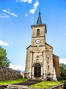
The village church of Saint-Ferréol in Fontenelle-Montby was built in the 18th century. A former manor house now serves as a farm.
population
| Population development | |
|---|---|
| year | Residents |
| 1962 | 126 |
| 1968 | 134 |
| 1975 | 118 |
| 1982 | 104 |
| 1990 | 106 |
| 1999 | 90 |
| 2005 | 103 |
| 2016 | 93 |
With 92 inhabitants (as of January 1, 2017) Fontenelle-Montby is one of the smallest communities in the Doubs department. After the number of inhabitants had decreased significantly in the first half of the 20th century (223 people were counted in 1911), only relatively minor fluctuations have been recorded since then.
Economy and Infrastructure
Fontenelle-Montby was until well into the 20th century a village dominated by agriculture (arable farming, fruit growing and cattle breeding) and forestry. In addition, there are now some local small businesses. In the meantime, the village has also turned into a residential community. Many workers are therefore commuters who work in the larger towns in the area.
The place is off the major thoroughfares on a department road that leads from Rougemont to Clerval . The closest connection to the A36 motorway is around ten kilometers away. Further road connections exist with Autechaux , Romain, Nans and Uzelle.
literature
- Le Patrimoine des Communes du Doubs. Volume 2, Flohic Editions, Paris 2001, ISBN 2-84234-087-6 , pp. 1102-1104.

