
Villers-sous-Montrond
| Villers-sous-Montrond | ||
|---|---|---|
|
||
| region | Bourgogne-Franche-Comté | |
| Department | Doubs | |
| Arrondissement | Besançon | |
| Canton | Ornans | |
| Community association | Loue-Lison | |
| Coordinates | 47 ° 9 ' N , 6 ° 5' E | |
| height | 444-624 m | |
| surface | 6.33 km 2 | |
| Residents | 210 (January 1, 2017) | |
| Population density | 33 inhabitants / km 2 | |
| Post Code | 25620 | |
| INSEE code | 25628 | |
 Mairie Villers-sous-Montrond |
||

Villers-sous-Montrond is a French municipality with 210 inhabitants (as of January 1, 2017) in the Doubs department in the region of Bourgogne Franche-Comté .
geography
Villers-sous-Montrond is located 470 m above sea level, about eleven kilometers south-southeast of the city of Besançon (as the crow flies). The village extends in the Jura , on the first plateau between the Jura ridge in the north and the Rocher de Punay in the south.
The area of the 6.33 km² large municipality covers a section of the stratified landscape of the western French Jura. The main part of the area is taken up by the Villers plateau, which is an average of 450 m. It is mostly made up of arable and meadow land. Apart from a few short rivulets, the entire plateau has no surface watercourses because the rainwater seeps into the karstified subsoil . A terrain step 50 to 80 meters high leads south to the next higher layer step , the height of Malbrans. On the ridge of the Rocher de Punay (southern border), the highest point in Villers-sous-Montrond is reached at 624 m. To the north, the municipal area extends with a narrow tip over the plateau into the wooded area of the Bois l'Essart .
Neighboring communities of Villers-sous-Montrond are Tarcenay-Foucherans in the east, Malbrans in the south and Montrond-le-Château and Mérey-sous-Montrond in the west.
history
In the Middle Ages, Villers was part of the Montrond lordship. Together with Franche-Comté , the village came to France with the Peace of Nijmegen in 1678. Today Villers-sous-Montrond is a member of the Loue-Lison municipality .
Attractions
The village church of Saint-Didier in Villers-sous-Montrond was built in the 18th century on the site of an earlier church and has a rich interior (mostly from the 18th century). In the center there are numerous farmhouses in the characteristic style of Franche-Comté from the 17th to 19th centuries.
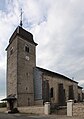
Saint Didier Church

Chateau


population
| Population development | |
|---|---|
| year | Residents |
| 1962 | 95 |
| 1968 | 113 |
| 1975 | 112 |
| 1982 | 139 |
| 1990 | 148 |
| 1999 | 163 |
| 2006 | 159 |
| 2016 | 211 |
With 210 inhabitants (January 1, 2017) Villers-sous-Montrond is one of the small communities in the Doubs department. After the population had decreased significantly in the first half of the 20th century (203 people were counted in 1891), the population has continued to grow steadily since the mid-1970s.
Economy and Infrastructure
Until well into the 20th century, Villers-sous-Montrond was a village characterized by agriculture (arable farming, fruit growing and cattle breeding) and forestry. In addition, there are now some local small businesses. In the meantime, the village has also turned into a residential community. Many workers are commuters who work in the larger towns in the area.
The village is off the main thoroughfares, but is easily accessible from the main D67 road from Besançon to Ornans . There are other road links with Mérey-sous-Montrond and Malbrans.
literature
- Le Patrimoine des Communes du Doubs. Volume 2, Flohic Editions, Paris 2001, ISBN 2-84234-087-6 , pp. 861-862.