Mouthier-Haute-Pierre
| Mouthier-Haute-Pierre | ||
|---|---|---|

|
|
|
| region | Bourgogne-Franche-Comté | |
| Department | Doubs | |
| Arrondissement | Besançon | |
| Canton | Ornans | |
| Community association | Loue-Lison | |
| Coordinates | 47 ° 2 ′ N , 6 ° 17 ′ E | |
| height | 370-867 m | |
| surface | 12.13 km 2 | |
| Residents | 335 (January 1, 2017) | |
| Population density | 28 inhabitants / km 2 | |
| Post Code | 25930 | |
| INSEE code | 25415 | |
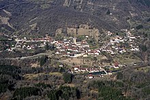
 Mouthier-Haute-Pierre: View of the village from the Rue de Longeville in SW |
||
Mouthier-Haute-Pierre is a French commune with a population of 335 (as at 1st January 2017) in the Doubs department in the region of Bourgogne Franche-Comté .
geography
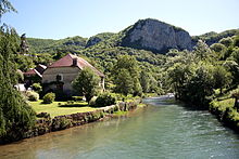
Mouthier-Haute-Pierre is 408 m above sea level, twelve kilometers southeast of Ornans and about 29 kilometers southeast of the city of Besançon (as the crow flies). The village extends in the Jura , in the narrow valley of the upper Loue , which is deeply cut into the surrounding plateau, near the karst source of the Loue. The valley basin is dominated by the striking limestone walls and projections de Roche de Hautepierre and Rocher du Moine .
The area of the 12.13 km² municipal area covers a section of the French Jura. The central part of the area is occupied by the Mouthier basin, the uppermost valley widening of the Loue. The basin is cut almost 400 m deep into the surrounding plateaus and the Loue flows through it from south-east to north-west. Its steep slopes are criss-crossed and crowned by characteristic limestone walls. In the north, the communal soil extends to the rock formations of the Roche de Hautepierre (up to 800 m) and to the edge of the Hautepierre plateau. Directly opposite on the south side of the basin are the Rochers du Capucin with the Rocher du Moine viewpoint (also up to 800 m). On the ridge of the Belvoir , the highest elevation of Mouthier-Haute-Pierre is reached here at 867 m. To the southeast, the municipal area extends into the lower section of the Gorges de Nouailles , a wild canyon that was created by the Loue. The karst spring Source du Pontet and the cave Grotte des Faux-Monnayeurs are just before the entrance to the gorge .
The community consists of the two districts Mouthier Haut ( 440 m ) on the northern slope of the Loue valley below the Roche de Hautepierre and Mouthier Bas ( 390 m ) on the Loue. Neighboring municipalities of Mouthier-Haute-Pierre are
- Les Premiers Sapins with Athose in the north and Hautepierre-le-Châtelet in the east,
- Aubonne , Ouhans , Renédale and Évillers in the south,
- Longeville and Lods to the west.
history
Mouthier's beginnings go back to the founding of the Benedictine monastery of Saint-Pierre de la Haute-Pierre in the 9th century. The monks made the area arable and thus laid the foundation stone for settlement. In 1639 the village was affected by the troops of Duke Bernhard von Sachsen-Weimar . Together with Franche-Comté , it came to France with the Peace of Nijmegen in 1678. It was not until 1962 that the official parish name was changed from Mouthier to Mouthier-Haute-Pierre. Today Mouthier-Haute-Pierre is a member of the Loue-Lison community .
Attractions
The Saint-Laurent church originally dates from the 12th century. The church was given its present shape when it was largely rebuilt in the 16th century in the Gothic flamboyant style. It is richly decorated , including statues from the 15th century, an altar from the 17th century and a pulpit and choir stalls from the 18th century. Hardly any remains of the former priory church are visible, but the priory building from the 18th century has been preserved. The old town center is characterized by narrow streets lined with numerous town houses and winegrowers' houses in the characteristic style of Franche-Comté from the 16th to 18th centuries. The small Musée Phisalix in the Mairie (parish hall) shows a collection on the natural history and fauna of the region. A stone bridge that was built in the 16th century spans the Loue.
population
| Population development | |
|---|---|
| year | Residents |
| 1962 | 377 |
| 1968 | 315 |
| 1975 | 338 |
| 1982 | 360 |
| 1990 | 356 |
| 1999 | 343 |
| 2006 | 318 |
| 2016 | 328 |
With 335 inhabitants (January 1, 2017), Mouthier-Haute-Pierre is one of the small communities in the Doubs department. After the population had decreased markedly in the first half of the 20th century (831 people were still counted in 1881), only relatively minor fluctuations have been recorded since the early 1960s.
Economy and Infrastructure
For a long time, Mouthier-Haute-Pierre was a village characterized by agriculture (with viticulture, which is now completely abandoned) and small businesses. The water power of the Loue was used early on for the operation of mills, sawmills and the iron processing industry. Today there are some small and medium-sized businesses, including a hydropower plant, various craft businesses and retail businesses. The cherry production is important. Some workers are also commuters who work in the larger towns in the area.
The village is well developed in terms of traffic. It is located on the D67 departmental road from Ornans to Pontarlier . Another road connection is with Hautepierre-le-Châtelet.
literature
- Le Patrimoine des Communes du Doubs. Volume 2, Flohic Editions, Paris 2001, ISBN 2-84234-087-6 , pp. 850-851.


