
Aïssey
| Aïssey | ||
|---|---|---|
.svg)
|
|
|
| region | Bourgogne-Franche-Comté | |
| Department | Doubs | |
| Arrondissement | Besançon | |
| Canton | Baume-les-Dames | |
| Community association | Doubs Baumois | |
| Coordinates | 47 ° 16 ' N , 6 ° 20' E | |
| height | 370-599 m | |
| surface | 10.67 km 2 | |
| Residents | 169 (January 1, 2017) | |
| Population density | 16 inhabitants / km 2 | |
| Post Code | 25360 | |
| INSEE code | 25009 | |

Aïssey is a French municipality with 169 inhabitants (as of January 1 2017) in Doubs in the region Bourgogne Franche-Comté .
geography

Aïssey is located at 427 m, ten kilometers south of Baume-les-Dames and about 24 km east of the city of Besançon (as the crow flies). The village extends in the Jura , on the so-called first plateau, a wide basin between the Jura rim chain (Côte) in the north and the high plateaus in the southeast, east of the valley of the Audeux .
The area of the 10.67 km² large municipality covers a section of the French Jura. The main part of the area is occupied by the wide first Jura plateau, which is 420 m on average. It forms a wide, partially karstified basin. From south to north the plateau is crossed by the lowlands of the Audeux, with the brook gradually deepening into the plateau in a winding valley. In the Aïssey area, the plateau is predominantly made up of arable and meadow land. To the north, the communal soil extends into the forest areas of the Grand Bois and Bois de la Faye . To the southeast, the community area extends over an approximately 150 m high step on the adjacent high plateau of Mont, on which the highest point of Aïssey is reached at 599 m. In the far south the area extends into the valley of the upper Audeux, in which the Grâce-Dieu monastery is located.
Neighboring municipalities of Aïssey are Dammartin-les-Templiers and Saint-Juan in the north, Orsans in the east, Chaux-lès-Passavant , Magny-Châtelard and Côtebrune in the south and Glamondans in the west.
history
In the Middle Ages, Aïssey belonged to the Passavant rule, which had been under the suzerainty of the Counts of Montbéliard since the 14th century. Together with Franche-Comté, the village came to France with the Peace of Nijmegen in 1678. On June 18, 1940, Aïssey was almost completely destroyed by German troops.
Attractions
The church of Aïssey shows the modern architecture of the 20th century. The Saint-Nicolas chapel on the edge of the forest above the village dates from the 16th century . Various farmhouses in the characteristic style of Franche-Comté from the 18th to 19th centuries have been preserved in the town center.
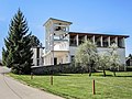
Saint-Nicolas church

Saint-Nicolas chapel


population
| Population development | |
|---|---|
| year | Residents |
| 1962 | 171 |
| 1968 | 160 |
| 1975 | 144 |
| 1982 | 137 |
| 1990 | 163 |
| 1999 | 166 |
| 2006 | 165 |
| 2009 | 162 |
| 2016 | 175 |
With 169 inhabitants (as of January 1, 2017), Aïssey is one of the small communities in the Doubs department. After the population had decreased significantly in the first half of the 20th century (271 people were counted in 1886), slight population growth has been recorded since the mid-1980s.
Economy and Infrastructure
Until well into the 20th century, Aïssey was a village dominated by agriculture (arable farming, fruit growing and cattle breeding) and forestry. In addition, there are now some local small businesses. In the meantime, the village has also turned into a residential community. Many employed people are commuters who work in the larger towns in the area or in the Besançon agglomeration.
The village is located away from the major thoroughfares on a departmental road that leads from Besançon to Sancey-le-Grand . Further road connections exist with Baume-les-Dames , Ornans and Orsans.