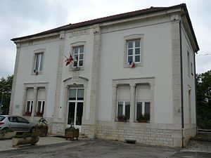
Dannemarie-sur-Crète
| Dannemarie-sur-Crète | ||
|---|---|---|
|
|
||
| region | Bourgogne-Franche-Comté | |
| Department | Doubs | |
| Arrondissement | Besançon | |
| Canton | Besançon-1 | |
| Community association | Grand Besançon | |
| Coordinates | 47 ° 12 ' N , 5 ° 52' E | |
| height | 239-303 m | |
| surface | 4.06 km 2 | |
| Residents | 1,473 (January 1, 2017) | |
| Population density | 363 inhabitants / km 2 | |
| Post Code | 25410 | |
| INSEE code | 25195 | |
 Dannemarie-Velesmes train station |
||
Dannemarie-sur-Crète is a French commune with 1,473 inhabitants (as of January 1 2017) in Doubs in the region Bourgogne Franche-Comté .
geography
Dannemarie-sur-Crète is located at 290 m , about 13 kilometers west-southwest of the city of Besançon (beeline). The village extends on a long hill in the gently undulating landscape between the rivers of Doubs in the south and Ognon (in the north).
The area of the 4.06 km² municipal area includes a section north of the Doubstal. The area is delimited in the south by the main road N73 , which leads from Besançon to Dole and in the west by the valley of the Ringeard. This drains the area south to the Doubs. The landscape, partly with arable land and meadow, partly with forest, shows only minor differences in relief. The watershed between Doubs and Ognon runs on the heights of Dannemarie. At 303 m, the highest point of Dannemarie-sur-Crète is reached here.
Neighboring communities of Dannemarie-sur-Crète are Villers-Buzon in the north, Chemaudin et Vaux with Chemaudin in the east, Grandfontaine , Velesmes-Essarts and Saint-Vit in the south and Pouilley-Français in the west.
history
Dannemarie is first mentioned in a document in 1110 under the name Donna Maria ; The name Dompna Maria has been handed down from 1275 . In the Middle Ages, Dannemarie first belonged to the Corcondray lordship, after which it formed its own lordship. Together with Franche-Comté , the village finally came to France with the Peace of Nijmegen in 1678. To avoid confusion with other communities of the same name, Dannemarie was officially renamed Dannemarie-sur-Crète in 1922.
Attractions
The Notre-Dame de l'Assomption de la Vierge church was rebuilt in 1624 on the site of a dilapidated medieval church (12th century). The current building of the castle dates from the 18th century.
population
| Population development | |
|---|---|
| year | Residents |
| 1962 | 250 |
| 1968 | 239 |
| 1975 | 444 |
| 1982 | 653 |
| 1990 | 774 |
| 1999 | 938 |
| 2016 | 1448 |
With 1,473 inhabitants (as of January 1, 2017), Dannemarie-sur-Crète is one of the smaller communities in the Doubs department. After the population in the first half of the 20th century had always been in the range between 150 and 190 people, a striking population growth has been recorded since the beginning of the 1950s. Since then the number of inhabitants has increased more than fivefold.
Economy and Infrastructure
Dannemarie-sur-Crète was a village dominated by agriculture (arable farming, fruit growing and cattle breeding) well into the 20th century. In addition, there are various small and medium-sized businesses today. An industrial and commercial zone developed on the main road N73 since the 1970s. Mainly companies from the machine tool construction, civil engineering and transport sectors settled here. In the meantime, the village has also turned into a residential community. Many workers are therefore commuters who go to work in the Besançon agglomeration. Dannemarie-sur-Crète has an agricultural vocational school.
The village is well developed in terms of traffic. It is close to the main road N73 that goes from Besançon to Dole . The nearest connection to the A36 motorway , which crosses the municipality, is about eight kilometers away. There are further road connections with Pouilley-Français, Chemaudin and Velesmes-Essarts. Dannemarie-sur-Crète has a station on the railway line from Besançon to Dijon .
